IMAGES TAKEN NEAR TO
Elwick, HARTLEPOOL, TS27 3EW
Introduction
This page details the photographs taken nearby to TS27 3EW by members of the Geograph project.
The Geograph project started in 2005 with the aim of publishing, organising and preserving representative images for every square kilometre of Great Britain, Ireland and the Isle of Man.

There are currently over 7.5m images from over14,400 individuals and you can help contribute to the project by visiting https://www.geograph.org.uk
Image Map (Loading...)


Getting Data...Please wait
Leaflet Map data © OpenStreetMap
Images are licensed for reuse under creativecommons.org/licenses/by-sa/2.0
Notes
- Clicking on the map will re-center to the selected point.
- The higher the marker number, the further away the image location is from the centre of the postcode.
Image Listing (6 Images Found)
Images are licensed for reuse under creativecommons.org/licenses/by-sa/2.0
Image
Details
Distance
1
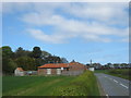
Cottages at Rixown
Formerly the site of Three Nooks Farm
Image: © Peter Robinson
Taken: 28 Apr 2012
0.02 miles
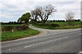
2
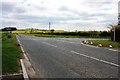
Road junction near Rixowen
This photograph shows a view of the road junction formed by the intersection of the B1280 road (from where the picture was taken) and the minor road from Hurworth Burn. Whangdon Hill and the transmitter that stands upon it can just be seen on the horizon (just above the Trimdon sign). The picture was taken looking in a south-south-easterly direction towards the A19(T) road.
Image: © Philip Barker
Taken: 14 May 2010
0.03 miles
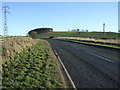
3
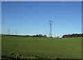
Grazing and power lines
North of the B1280.
Image: © JThomas
Taken: 11 Jan 2014
0.11 miles
5
Road junction near Farden Hill
This photograph shows a view of the road junction formed by the intersection of the B1280 road (from where the picture was taken) and the minor road from Sheraton. The pylon run that passes through the north-east corner of the grid-square is just visible in the left-hand side of the image. The picture was taken looking in an east-north-easterly direction towards Sheraton Hall Farm.
Image: © Philip Barker
Taken: 14 May 2010
0.20 miles