IMAGES TAKEN NEAR TO
Burns Close, HARTLEPOOL, TS27 3AT
Introduction
This page details the photographs taken nearby to Burns Close, TS27 3AT by members of the Geograph project.
The Geograph project started in 2005 with the aim of publishing, organising and preserving representative images for every square kilometre of Great Britain, Ireland and the Isle of Man.

There are currently over 7.5m images from over14,400 individuals and you can help contribute to the project by visiting https://www.geograph.org.uk
Image Map
Images are licensed for reuse under creativecommons.org/licenses/by-sa/2.0
Notes
- Clicking on the map will re-center to the selected point.
- The higher the marker number, the further away the image location is from the centre of the postcode.
Image Listing (8 Images Found)
Images are licensed for reuse under creativecommons.org/licenses/by-sa/2.0
Image
Details
Distance
1
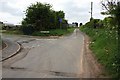
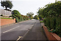
Road Junction on Butts Lane
This photograph shows a view of the road junction formed by the intersection of Burns Close (on the left) with Butts Lane (from where the photograph was taken). The picture was taken looking in a westerly direction towards Sheraton.
Image: © Philip Barker
Taken: 19 May 2010
0.02 miles
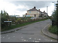
3
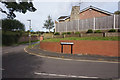
Burns Close, Hart
A small residential cul de sac off Butts Lane, stuck out in the fields.
Image: © Oliver Dixon
Taken: 14 Nov 2006
0.07 miles
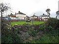
4
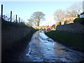
Parting of the ways, Hart
But both roads are a cul de sac for cars.
Image: © Oliver Dixon
Taken: 14 Nov 2006
0.18 miles