IMAGES TAKEN NEAR TO
Queensberry Avenue, HARTLEPOOL, TS26 9FW
Introduction
This page details the photographs taken nearby to Queensberry Avenue, TS26 9FW by members of the Geograph project.
The Geograph project started in 2005 with the aim of publishing, organising and preserving representative images for every square kilometre of Great Britain, Ireland and the Isle of Man.

There are currently over 7.5m images from over14,400 individuals and you can help contribute to the project by visiting https://www.geograph.org.uk
Image Map (Loading...)


Getting Data...Please wait
Leaflet Map data © OpenStreetMap
Images are licensed for reuse under creativecommons.org/licenses/by-sa/2.0
Notes
- Clicking on the map will re-center to the selected point.
- The higher the marker number, the further away the image location is from the centre of the postcode.
Image Listing (8 Images Found)
Images are licensed for reuse under creativecommons.org/licenses/by-sa/2.0
Image
Details
Distance
1
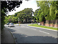
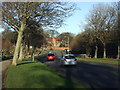
Elwick Road, Stranton, Hartlepool
At the junction with Catcote Road.
Image: © John Lucas
Taken: 8 Jul 2014
0.09 miles
2
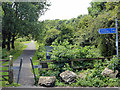
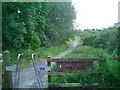
Footpath to Summerhill Country Park and Burn Valley Gardens
From Elwick Road.
Image: © John Lucas
Taken: 8 Jul 2014
0.14 miles
3
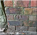
Hartlepool, Elwick Road
The benchmark is cut into the brick roadside wall on the south side of Elwick Road.
Image: © Mel Towler
Taken: 30 Jul 2022
0.15 miles
4
Hartlepool, Elwick Road
There is a benchmark cut into the brick roadside wall on the south side of Elwick Road. The mark is immediately to the right of the stone wall.
Image: © Mel Towler
Taken: 30 Jul 2022
0.15 miles
5
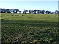
Family Wood, Elwick Road, Hartlepool.
Looking south west down path into Family Wood off Elwick Road, Hartlepool.
Image: © Richard Atkinson
Taken: 6 Jul 2005
0.16 miles
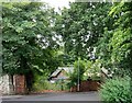
8

Entrance for Family Wood at Burn Valley in Hartlepool
Image: © Peter Robinson
Taken: 8 Dec 2013
0.25 miles