IMAGES TAKEN NEAR TO
Duke Street, HARTLEPOOL, TS26 8PU
Introduction
This page details the photographs taken nearby to Duke Street, TS26 8PU by members of the Geograph project.
The Geograph project started in 2005 with the aim of publishing, organising and preserving representative images for every square kilometre of Great Britain, Ireland and the Isle of Man.

There are currently over 7.5m images from over14,400 individuals and you can help contribute to the project by visiting https://www.geograph.org.uk
Image Map
Images are licensed for reuse under creativecommons.org/licenses/by-sa/2.0
Notes
- Clicking on the map will re-center to the selected point.
- The higher the marker number, the further away the image location is from the centre of the postcode.
Image Listing (11 Images Found)
Images are licensed for reuse under creativecommons.org/licenses/by-sa/2.0
Image
Details
Distance
3
Crossroads on Hart Lane
This photograph shows a view of one of the many road intersections on Hart Lane. The red traffic light is pointing in the direction of Duke Street - opposite which is Jesmond Road. The picture was taken looking in a north-westerly direction towards Hart reservoirs.
Image: © Philip Barker
Taken: 4 Jun 2010
0.15 miles
4
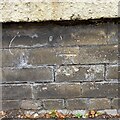
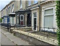
Hartlepool, 79 Grange Road
The benchmark is cut into the boundary wall of this property which is on the south side of Grange Road.
Image: © Mel Towler
Taken: 30 Jul 2022
0.17 miles
5
Hartlepool, 79 Grange Road
There is a benchmark cut into the boundary wall of this property which is on the south side of Grange Road.
Image: © Mel Towler
Taken: 30 Jul 2022
0.17 miles
6
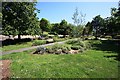
Park area near Hart Lane, Hartlepool
This photograph shows a view of a small park near North Cemetery on Hart Lane. The entrance to the park is on Ernest Street (behind the photographer). Hart Lane can just be seen running alongside the cemetery wall. The picture was taken looking in an easterly direction towards Hartlepool Bay.
Image: © Philip Barker
Taken: 4 Jun 2010
0.19 miles
7
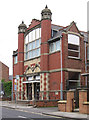
Hartlepool - Grange Road Methodist Church
Image: © Dave Bevis
Taken: 31 May 2014
0.22 miles
8

Grange Road looking north up Tankerville St
Image: © Richard Lees
Taken: Unknown
0.22 miles
9
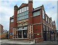
Hartlepool, Grange Road Methodist Church
According to the OS benchmark database there is a benchmark cut into the left end of the small boundary wall alongside the access ramp. Nothing was found.
Image: © Mel Towler
Taken: 30 Jul 2022
0.22 miles
10
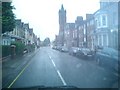
Grange Road, Hartlepool.
Looking east down Grange Road to St. Paul's Church on a wet day in Hartlepool.
Image: © Richard Atkinson
Taken: 6 Jul 2005
0.23 miles