IMAGES TAKEN NEAR TO
Welldeck Road, HARTLEPOOL, TS26 8JT
Introduction
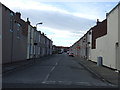
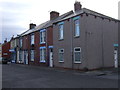
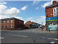
This page details the photographs taken nearby to Welldeck Road, TS26 8JT by members of the Geograph project.
The Geograph project started in 2005 with the aim of publishing, organising and preserving representative images for every square kilometre of Great Britain, Ireland and the Isle of Man.

There are currently over 7.5m images from over14,400 individuals and you can help contribute to the project by visiting https://www.geograph.org.uk
Image Map (Loading...)


Getting Data...Please wait
Leaflet Map data © OpenStreetMap
Images are licensed for reuse under creativecommons.org/licenses/by-sa/2.0
Notes
- Clicking on the map will re-center to the selected point.
- The higher the marker number, the further away the image location is from the centre of the postcode.
Image Listing (5 Images Found)
Images are licensed for reuse under creativecommons.org/licenses/by-sa/2.0
Image
Details
Distance
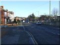
1
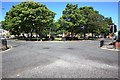
Crossroads on Hart Lane
This photograph shows a view of one of the many road intersections on Hart Lane. The red traffic light is pointing in the direction of Duke Street - opposite which is Jesmond Road. The picture was taken looking in a north-westerly direction towards Hart reservoirs.
Image: © Philip Barker
Taken: 4 Jun 2010
0.12 miles