IMAGES TAKEN NEAR TO
Alma Street, HARTLEPOOL, TS26 8AG
Introduction
This page details the photographs taken nearby to Alma Street, TS26 8AG by members of the Geograph project.
The Geograph project started in 2005 with the aim of publishing, organising and preserving representative images for every square kilometre of Great Britain, Ireland and the Isle of Man.

There are currently over 7.5m images from over14,400 individuals and you can help contribute to the project by visiting https://www.geograph.org.uk
Image Map (Loading...)


Getting Data...Please wait
Leaflet Map data © OpenStreetMap
Images are licensed for reuse under creativecommons.org/licenses/by-sa/2.0
Notes
- Clicking on the map will re-center to the selected point.
- The higher the marker number, the further away the image location is from the centre of the postcode.
Image Listing (29 Images Found)
Images are licensed for reuse under creativecommons.org/licenses/by-sa/2.0
Image
Details
Distance
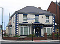
1
Hartlepool - Royal Naval Association building
On Murray Street.
Image: © Dave Bevis
Taken: 31 May 2014
0.02 miles
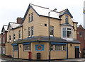
2
Hartlepool - surgery at Murray Street
Junction with Victoria Road.
Image: © Dave Bevis
Taken: 31 May 2014
0.06 miles
3
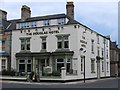
Hartlepool - The Douglas Hotel
At junction of Murray Street with Grange Road.
Image: © Dave Bevis
Taken: 31 May 2014
0.06 miles
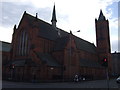
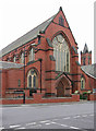
5
Hartlepool, St Paul's Church
The benchmark is cut into the boundary and roadside wall of the church which is on the south side of Grange Road.
Image: © Mel Towler
Taken: 30 Jul 2022
0.07 miles
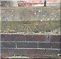
6
Hartlepool, St Paul's Church
There is a benchmark cut into the boundary and roadside wall of the church which is on the south side of Grange Road. The mark is cut into a coping stone.
Image: © Mel Towler
Taken: 30 Jul 2022
0.08 miles
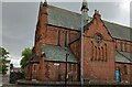
9
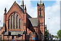
Hartlepool - St Joseph's Church
Roman Catholic church on St Paul's Road. The red-brick tower on the extreme right of the photo belongs to the Anglican St Paul's Church (seeImage).
Image: © Dave Bevis
Taken: 31 May 2014
0.11 miles