IMAGES TAKEN NEAR TO
Cornflower Close, HARTLEPOOL, TS26 0WJ
Introduction
This page details the photographs taken nearby to Cornflower Close, TS26 0WJ by members of the Geograph project.
The Geograph project started in 2005 with the aim of publishing, organising and preserving representative images for every square kilometre of Great Britain, Ireland and the Isle of Man.

There are currently over 7.5m images from over14,400 individuals and you can help contribute to the project by visiting https://www.geograph.org.uk
Image Map
Images are licensed for reuse under creativecommons.org/licenses/by-sa/2.0
Notes
- Clicking on the map will re-center to the selected point.
- The higher the marker number, the further away the image location is from the centre of the postcode.
Image Listing (9 Images Found)
Images are licensed for reuse under creativecommons.org/licenses/by-sa/2.0
Image
Details
Distance
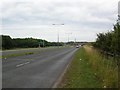
3
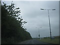
The A179 eastbound towards Hartlepool
Image: © Peter Robinson
Taken: 14 Jul 2013
0.14 miles
4
Looking across Hart Road
Hart road (A179). To the left it joins the A19 several miles further on. To the right is a roundabout about 100 yards from here.
Image: © DS Pugh
Taken: 5 Aug 2006
0.15 miles
5
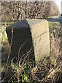
Old Boundary Marker by the A179, Hart Road, Throston Grange
Municipal Boundary Marker by the A179, in parish of Hartlepool (Hartlepool District), Hart Road, Throston Grange, on verge of dual carriageway. North side of road, accessible by footpath through trees.
Inscription reads:-
HARTLEPOOL
(?)
1936
Surveyed
Milestone Society National ID: DU_HART01pb
Image: © Milestone Society
Taken: 31 Dec 2017
0.17 miles
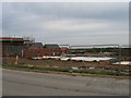
6

Sainsbury's on Bishop Cuthbert Estate, Hartlepool
Image: © Peter Robinson
Taken: 30 May 2010
0.19 miles
8
Hart road
The sign for the roundabout can be seen. Here the A1086 (left) and A1049 (straight ahead) meet the A179 which curves round to the right.
Image: © DS Pugh
Taken: 5 Aug 2006
0.24 miles