IMAGES TAKEN NEAR TO
Mereston Close, HARTLEPOOL, TS26 0LW
Introduction
This page details the photographs taken nearby to Mereston Close, TS26 0LW by members of the Geograph project.
The Geograph project started in 2005 with the aim of publishing, organising and preserving representative images for every square kilometre of Great Britain, Ireland and the Isle of Man.

There are currently over 7.5m images from over14,400 individuals and you can help contribute to the project by visiting https://www.geograph.org.uk
Image Map
Images are licensed for reuse under creativecommons.org/licenses/by-sa/2.0
Notes
- Clicking on the map will re-center to the selected point.
- The higher the marker number, the further away the image location is from the centre of the postcode.
Image Listing (3 Images Found)
Images are licensed for reuse under creativecommons.org/licenses/by-sa/2.0
Image
Details
Distance
2
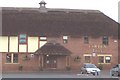
Golf Club
High Throston Golf Clubhouse.
Image: © Colin Coates
Taken: 10 Dec 2005
0.19 miles
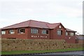
3

The ALDI store on Dunston Road
This photograph shows a view of the ALDI store on Dunston Road (near its junction with Hart Lane). One of the street lights on Hart Lane can just be seen in the right-hand side of the image. The Golden Lion hostelry lies just to the left of the red car - see here: Image The picture was taken looking in a west-north-westerly direction towards Whelly Hill.
Image: © Philip Barker
Taken: 4 Jun 2010
0.24 miles