IMAGES TAKEN NEAR TO
Oxford Road, HARTLEPOOL, TS25 5NH
Introduction
This page details the photographs taken nearby to Oxford Road, TS25 5NH by members of the Geograph project.
The Geograph project started in 2005 with the aim of publishing, organising and preserving representative images for every square kilometre of Great Britain, Ireland and the Isle of Man.

There are currently over 7.5m images from over14,400 individuals and you can help contribute to the project by visiting https://www.geograph.org.uk
Image Map (Loading...)


Getting Data...Please wait
Leaflet Map data © OpenStreetMap
Images are licensed for reuse under creativecommons.org/licenses/by-sa/2.0
Notes
- Clicking on the map will re-center to the selected point.
- The higher the marker number, the further away the image location is from the centre of the postcode.
Image Listing (2 Images Found)
Images are licensed for reuse under creativecommons.org/licenses/by-sa/2.0
Image
Details
Distance
2
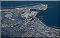
Hartlepool from the air
The light covering of snow emphasises the grid pattern of the streets in the suburbs. Hartlepool FC's stadium can be seen near the centre of the photo. The Headland is prominent beyond the docks.
Viewed from a Prague bound flight from Glasgow.
Image: © Thomas Nugent
Taken: 11 Dec 2017
0.23 miles