IMAGES TAKEN NEAR TO
Ettrick Walk, HARTLEPOOL, TS25 4BB
Introduction
This page details the photographs taken nearby to Ettrick Walk, TS25 4BB by members of the Geograph project.
The Geograph project started in 2005 with the aim of publishing, organising and preserving representative images for every square kilometre of Great Britain, Ireland and the Isle of Man.

There are currently over 7.5m images from over14,400 individuals and you can help contribute to the project by visiting https://www.geograph.org.uk
Image Map (Loading...)


Getting Data...Please wait
Leaflet Map data © OpenStreetMap
Images are licensed for reuse under creativecommons.org/licenses/by-sa/2.0
Notes
- Clicking on the map will re-center to the selected point.
- The higher the marker number, the further away the image location is from the centre of the postcode.
Image Listing (5 Images Found)
Images are licensed for reuse under creativecommons.org/licenses/by-sa/2.0
Image
Details
Distance
3
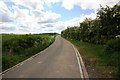
Brierton Lane
This photograph shows a view of Brierton Lane as it passes through the grid-square. The picture was taken looking in a west-south-westerly direction towards Brierton Heights Farm.
Image: © Philip Barker
Taken: 28 May 2010
0.22 miles
4
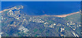
Hartlepool from the air
Looking over Rift House towards the coast and the docks.
Taken at around 37,000 feet by mobile phone, from a Prague bound flight from Edinburgh.
Image: © Thomas Nugent
Taken: 10 Oct 2022
0.25 miles