IMAGES TAKEN NEAR TO
Northwold Close, HARTLEPOOL, TS25 2LP
Introduction
This page details the photographs taken nearby to Northwold Close, TS25 2LP by members of the Geograph project.
The Geograph project started in 2005 with the aim of publishing, organising and preserving representative images for every square kilometre of Great Britain, Ireland and the Isle of Man.

There are currently over 7.5m images from over14,400 individuals and you can help contribute to the project by visiting https://www.geograph.org.uk
Image Map (Loading...)


Getting Data...Please wait
Leaflet Map data © OpenStreetMap
Images are licensed for reuse under creativecommons.org/licenses/by-sa/2.0
Notes
- Clicking on the map will re-center to the selected point.
- The higher the marker number, the further away the image location is from the centre of the postcode.
Image Listing (4 Images Found)
Images are licensed for reuse under creativecommons.org/licenses/by-sa/2.0
Image
Details
Distance
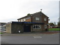
1
Mowbray Road, Hartlepool
National Cycle Network goes through a series of right angled bends on its route through the suburbs of Hartlepool.
Image: © Oliver Dixon
Taken: 6 Jul 2016
0.15 miles

3
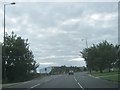
Multiple traffic lights at A689 junction with industrial estate road
Image: © Peter Robinson
Taken: 14 Sep 2013
0.23 miles