IMAGES TAKEN NEAR TO
HARTLEPOOL, TS25 2EG
Introduction
This page details the photographs taken nearby to TS25 2EG by members of the Geograph project.
The Geograph project started in 2005 with the aim of publishing, organising and preserving representative images for every square kilometre of Great Britain, Ireland and the Isle of Man.

There are currently over 7.5m images from over14,400 individuals and you can help contribute to the project by visiting https://www.geograph.org.uk
Image Map (Loading...)


Getting Data...Please wait
Leaflet Map data © OpenStreetMap
Images are licensed for reuse under creativecommons.org/licenses/by-sa/2.0
Notes
- Clicking on the map will re-center to the selected point.
- The higher the marker number, the further away the image location is from the centre of the postcode.
Image Listing (3 Images Found)
Images are licensed for reuse under creativecommons.org/licenses/by-sa/2.0
Image
Details
Distance
1
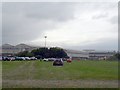
Park and Ride, Corus site, Tall Ships 2010
The 2010 Tall Ships race ended at Hartlepool, so traffic was banned from the town centre and temporary Park and Ride schemes were operated. This car park was on the Corus site.
The furthest building is the 24 inch pipe rolling mill, I don't know what the nearer buildings are used for.
Image: © Rich Tea
Taken: 9 Aug 2010
0.15 miles
2
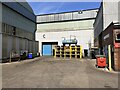
Hartlepool 20-inch Pipe Mill
Owned by Tata Steel, Hartlepool 20-inch Pipe Mill has the capacity to produce 220,000 tonnes of carbon steel tube annually.
Image: © Adrian Taylor
Taken: 9 Jul 2022
0.15 miles
3
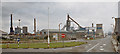
British Steel Hartlepool, 1970
View Southwest from the British Steel Hartlepool South Works entrance on Brenda Road (B1277). The main structure in the centre of the photograph is a blast furnace whilst to the left hand side is a coke ovens battery coal bunker with gas holder behind.
Image: © Ben Brooksbank
Taken: 13 Sep 1970
0.19 miles