IMAGES TAKEN NEAR TO
Sydenham Road, HARTLEPOOL, TS25 1QB
Introduction
This page details the photographs taken nearby to Sydenham Road, TS25 1QB by members of the Geograph project.
The Geograph project started in 2005 with the aim of publishing, organising and preserving representative images for every square kilometre of Great Britain, Ireland and the Isle of Man.

There are currently over 7.5m images from over14,400 individuals and you can help contribute to the project by visiting https://www.geograph.org.uk
Image Map (Loading...)


Getting Data...Please wait
Leaflet Map data © OpenStreetMap
Images are licensed for reuse under creativecommons.org/licenses/by-sa/2.0
Notes
- Clicking on the map will re-center to the selected point.
- The higher the marker number, the further away the image location is from the centre of the postcode.
Image Listing (5 Images Found)
Images are licensed for reuse under creativecommons.org/licenses/by-sa/2.0
Image
Details
Distance
1
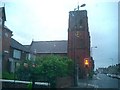
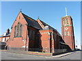
Stockton Road/Oxford Road junction
St Aidan's Church looking south along Stockton Road.
Image: © Richard Atkinson
Taken: 6 Jul 2005
0.12 miles
2
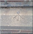
Ordnance Survey Rivet
This OS rivet can be found on the wall of St Aidan's Church. It marks a point 10.113m above mean sea level.
Image: © Adrian Dust
Taken: 17 Sep 2018
0.13 miles
5
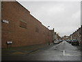
Casebourne Road, Longhill, Hartlepool
Commemorates Charles Casebourne, cement manufacturer. For more information see Image
Image: © John Lucas
Taken: 8 Jul 2014
0.25 miles