IMAGES TAKEN NEAR TO
Mainsforth Terrace, HARTLEPOOL, TS25 1NR
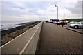
Introduction
This page details the photographs taken nearby to Mainsforth Terrace, TS25 1NR by members of the Geograph project.
The Geograph project started in 2005 with the aim of publishing, organising and preserving representative images for every square kilometre of Great Britain, Ireland and the Isle of Man.

There are currently over 7.5m images from over14,400 individuals and you can help contribute to the project by visiting https://www.geograph.org.uk
Image Map (Loading...)


Getting Data...Please wait
Leaflet Map data © OpenStreetMap
Images are licensed for reuse under creativecommons.org/licenses/by-sa/2.0
Notes
- Clicking on the map will re-center to the selected point.
- The higher the marker number, the further away the image location is from the centre of the postcode.
Image Listing (29 Images Found)
Images are licensed for reuse under creativecommons.org/licenses/by-sa/2.0
Image
Details
Distance
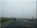
1
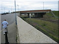
Bridge carrying A178 over East Coast Railway
Image: © Peter Robinson
Taken: 7 Aug 2011
0.08 miles
2
Sea Defences
For Coronation Drive, north of Seaton Carew
Image: © Kevin Waterhouse
Taken: 15 Jun 2023
0.08 miles
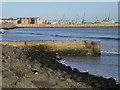
3
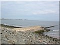
Between Hartlepool & Seaton Carew
Not sure what this is running out to sea. Probably a pipeline or similar structure.
Image: © DS Pugh
Taken: 5 Aug 2006
0.08 miles
4
Promenade and beach (view north)
This photograph shows a view of the promenade and beach near Newburn Bridge. The beach visible in the right-hand side of the picture is part of Carr House Sands. Hartlepool Bay can also be seen. The road in the left-hand side of the image is the A178 which runs between Seaton Carew and Hartlepool. The picture was taken looking in a northerly direction towards Hartlepool Marina.
Image: © Philip Barker
Taken: 29 May 2010
0.10 miles
5
Outfall at Newburn Bridge
Image: © Oliver Dixon
Taken: 19 Nov 2015
0.11 miles
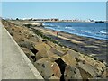
6
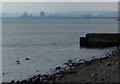
View across Hartlepool Bay
Teesside Steelworks is visible 4½ miles away across the bay.
Image: © Mat Fascione
Taken: 28 Aug 2017
0.11 miles
7
Hartlepool
Overlooking Hartlepool harbour.
Image: © Gordon BEACH
Taken: Unknown
0.11 miles
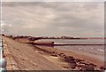
9
Promenade and Beach (view south)
This photograph shows a view of the promenade and beach near Newburn Bridge. The beach visible in the left-hand side of the picture is part of Carr House Sands. The picture was taken looking in a southerly direction towards Seaton Carew which is just visible near the horizon in the centre of the image.
Image: © Philip Barker
Taken: 29 May 2010
0.12 miles
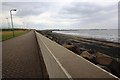
10
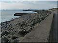
Sea defences along Hartlepool Bay at Carr House Sands
Image: © Mat Fascione
Taken: 28 Aug 2017
0.12 miles