IMAGES TAKEN NEAR TO
Jutland Road, HARTLEPOOL, TS25 1LR
Introduction
This page details the photographs taken nearby to Jutland Road, TS25 1LR by members of the Geograph project.
The Geograph project started in 2005 with the aim of publishing, organising and preserving representative images for every square kilometre of Great Britain, Ireland and the Isle of Man.

There are currently over 7.5m images from over14,400 individuals and you can help contribute to the project by visiting https://www.geograph.org.uk
Image Map
Images are licensed for reuse under creativecommons.org/licenses/by-sa/2.0
Notes
- Clicking on the map will re-center to the selected point.
- The higher the marker number, the further away the image location is from the centre of the postcode.
Image Listing (3 Images Found)
Images are licensed for reuse under creativecommons.org/licenses/by-sa/2.0
Image
Details
Distance
1
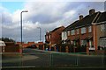
Ilkley Grove
A cul-de-sac off the Seaton Carew Road (B1276) and protected from it by barriers.
Image: © Mick Garratt
Taken: 9 Jan 2007
0.20 miles
2
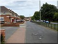
Seaton Lane, Hartlepool
Looking east along Seaton Lane (B1276). National Cycle Network route 14 follows the service road by the side of the main road.
Image: © Oliver Dixon
Taken: 6 Jul 2016
0.21 miles
3
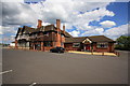
The Travellers Rest hostelry
This photograph shows a view of The Travellers Rest hostelry and its surrounding car parking area. The picture was taken looking in a north-easterly direction towards Carr House Sands.
Image: © Philip Barker
Taken: 28 May 2010
0.25 miles