IMAGES TAKEN NEAR TO
King Oswy Drive, HARTLEPOOL, TS24 9RN
Introduction
This page details the photographs taken nearby to King Oswy Drive, TS24 9RN by members of the Geograph project.
The Geograph project started in 2005 with the aim of publishing, organising and preserving representative images for every square kilometre of Great Britain, Ireland and the Isle of Man.

There are currently over 7.5m images from over14,400 individuals and you can help contribute to the project by visiting https://www.geograph.org.uk
Image Map
Images are licensed for reuse under creativecommons.org/licenses/by-sa/2.0
Notes
- Clicking on the map will re-center to the selected point.
- The higher the marker number, the further away the image location is from the centre of the postcode.
Image Listing (10 Images Found)
Images are licensed for reuse under creativecommons.org/licenses/by-sa/2.0
Image
Details
Distance
1

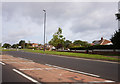
Roundabout in Hart Station
This photograph shows a view of a roundabout on the A1086 road in Hart Station. The roundabout facilitates the merging of traffic on the main road with that emerging from the two minor roads: Woodstock Way (bottom right) and King Oswy Drive (top left). The picture was taken looking in an easterly direction towards North Sands.
Image: © Philip Barker
Taken: 25 May 2010
0.05 miles
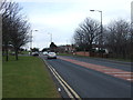

6
Hartlepool to Newcastle railway line
GBRf class 66 locomotive 66720 at Hart Station, on the outskirts of Hartlepool. The livery of 66720 was designed in 2011 by Emily Goodman, then aged six. The freight locomotive has a different design on each side representing night and day. This is a similar photograph to one taken in 1986 for the BBC Domesday Project. The land between the railway and the coast is a golf course. The chimney, all that remains of the former Steetley Magnesite works can be seen on the horizon, to the left of the railway line. See the Domesday Reloaded webpage http://www.bbc.co.uk/history/domesday/dblock/GB-448000-534000/picture/3 For another Domesday Reloaded image see Image
Image: © Martin Speck
Taken: 27 Jun 2012
0.20 miles
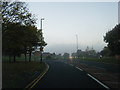
7
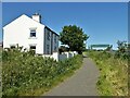
Cycle path following route of former railway
The start of the Hart to Haswell route at the site of the former Hart Station, with a footbridge across the remaining railway following a coastal route to Sunderland.
Image: © Kevin Waterhouse
Taken: 14 Jun 2023
0.22 miles
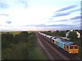
8
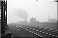
Hart Bank on a misty morning
Former LNER Q6 63410 pounds up the bank from Hartlepool with a rake of empty coal wagons on a misty morning. The nearest pair of rails is still in use, but those that the train is on have been replaced by the Hart to Haswell Walkway. https://www.geograph.org.uk/photo/3028930 was taken from a position directly above the photographer's viewpoint.
Image: © Alan Murray-Rust
Taken: 13 Apr 1965
0.22 miles
9
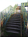
Footbridge at Hart Station
This footbridge crosses the Sunderland to Middlesbrough railway and links the Hart and Haswell Walkway with the path down to Crimdon Dene. The "wheeling ramp" on the right hand side of the steps is supposedly to aid cyclists get their bikes over the bridge, but in practice is very little help.
Image: © Oliver Dixon
Taken: 19 Nov 2015
0.24 miles
10
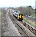
Heading for Sunderland
A rattly old DMU heads up the coast line out of Hartlepool towards Sunderland, although the sign in the cab suggests that the ultimate destination is Hexham.
Image: © Gordon Hatton
Taken: 18 Mar 2019
0.25 miles