IMAGES TAKEN NEAR TO
Wynnstay Gardens, HARTLEPOOL, TS24 8QJ
Introduction
This page details the photographs taken nearby to Wynnstay Gardens, TS24 8QJ by members of the Geograph project.
The Geograph project started in 2005 with the aim of publishing, organising and preserving representative images for every square kilometre of Great Britain, Ireland and the Isle of Man.

There are currently over 7.5m images from over14,400 individuals and you can help contribute to the project by visiting https://www.geograph.org.uk
Image Map
Images are licensed for reuse under creativecommons.org/licenses/by-sa/2.0
Notes
- Clicking on the map will re-center to the selected point.
- The higher the marker number, the further away the image location is from the centre of the postcode.
Image Listing (5 Images Found)
Images are licensed for reuse under creativecommons.org/licenses/by-sa/2.0
Image
Details
Distance
3

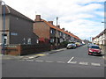
Disused Public House
Formerly the Lion Hotel, this building is now the target for arsonists and vandals
Image: © Colin Coates
Taken: 10 Dec 2005
0.24 miles
4

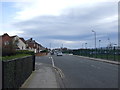
St Oswalds Church
Situated in Brougham Terrace this church was built in 1904
Image: © Colin Coates
Taken: 10 Dec 2005
0.24 miles
5
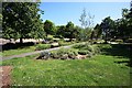
Park area near Hart Lane, Hartlepool
This photograph shows a view of a small park near North Cemetery on Hart Lane. The entrance to the park is on Ernest Street (behind the photographer). Hart Lane can just be seen running alongside the cemetery wall. The picture was taken looking in an easterly direction towards Hartlepool Bay.
Image: © Philip Barker
Taken: 4 Jun 2010
0.25 miles