IMAGES TAKEN NEAR TO
Nelson Street, HARTLEPOOL, TS24 7LU
Introduction
This page details the photographs taken nearby to Nelson Street, TS24 7LU by members of the Geograph project.
The Geograph project started in 2005 with the aim of publishing, organising and preserving representative images for every square kilometre of Great Britain, Ireland and the Isle of Man.

There are currently over 7.5m images from over14,400 individuals and you can help contribute to the project by visiting https://www.geograph.org.uk
Image Map
Images are licensed for reuse under creativecommons.org/licenses/by-sa/2.0
Notes
- Clicking on the map will re-center to the selected point.
- The higher the marker number, the further away the image location is from the centre of the postcode.
Image Listing (23 Images Found)
Images are licensed for reuse under creativecommons.org/licenses/by-sa/2.0
Image
Details
Distance
1
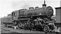
LMS Ivatt 2-6-0 at West Hartlepool Locomotive Depot
At rest on a Sunday is No. 43055 (built 9/50, withdrawn 7/67). Brought into this North Eastern stronghold in the 1950s, these 'foreign' intruders had a far shorter life than did the indigenous NER locomotives.
Image: © Ben Brooksbank
Taken: 13 Jun 1954
0.07 miles
2
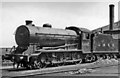
LNER J39 0-6-0 at West Hartlepool Locomotive Depot
View SE outside the Shed. This ex-North Eastern Depot serviced the railways of this important port and industrial centre, which had much freight traffic. The Depot was coded 51C in the Darlington District of BR(NER): in 1954 it had an allocation of 67 locomotives, comprising 61 steam:- 1 4-4-0, 1 2-6-0 (LMS-type), 14 0-8-0, 11 0-6-0, 3 4-6-2T, 25 0-6-0T, 6 0-4-4T; also 6 Diesel shunters. The photograph is of its sole Gresley J39 0-6-0, No. 64862 - which still had a tender marked 'LNER' 6½ years after Nationalisation.
Image: © Ben Brooksbank
Taken: 13 Jun 1954
0.08 miles
3
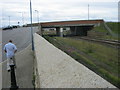
Bridge carrying A178 over East Coast Railway
Image: © Peter Robinson
Taken: 7 Aug 2011
0.09 miles
4
Between Hartlepool & Seaton Carew
Not sure what this is running out to sea. Probably a pipeline or similar structure.
Image: © DS Pugh
Taken: 5 Aug 2006
0.10 miles
5
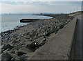
Ramp down to the beach near Newburn Bridge
No beach visible at high tide when the sea comes right up to the base of the Esplanade. Across the bay is the Headland area of Hartlepool Image
Image: © Oliver Dixon
Taken: 19 Nov 2015
0.12 miles
6
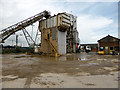
Concrete works,
Viewed from Burn Road, Hartlepool
Image: © John Lucas
Taken: 8 Jul 2014
0.13 miles
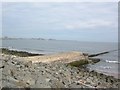
7
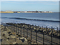
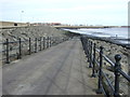
Sea defences along Hartlepool Bay at Carr House Sands
Image: © Mat Fascione
Taken: 28 Aug 2017
0.13 miles
10
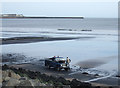
Gathering sea coal, Hartlepool Beach
There is still a living to be made from collecting the coal bought onto the beach twice daily by the tides from unerwater seams.
Image: © JThomas
Taken: 25 Feb 2012
0.14 miles