IMAGES TAKEN NEAR TO
Huckelhoven Way, HARTLEPOOL, TS24 7AE
Introduction
This page details the photographs taken nearby to Huckelhoven Way, TS24 7AE by members of the Geograph project.
The Geograph project started in 2005 with the aim of publishing, organising and preserving representative images for every square kilometre of Great Britain, Ireland and the Isle of Man.

There are currently over 7.5m images from over14,400 individuals and you can help contribute to the project by visiting https://www.geograph.org.uk
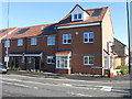
Image Map (Loading...)


Getting Data...Please wait
Leaflet Map data © OpenStreetMap
Images are licensed for reuse under creativecommons.org/licenses/by-sa/2.0
Notes
- Clicking on the map will re-center to the selected point.
- The higher the marker number, the further away the image location is from the centre of the postcode.
Image Listing (80 Images Found)
Images are licensed for reuse under creativecommons.org/licenses/by-sa/2.0
Image
Details
Distance
2
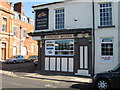
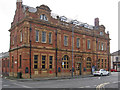
Princess Helena, Whitby Street, Hartlepool
Image: © Alex McGregor
Taken: 4 Oct 2010
0.07 miles
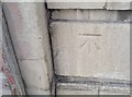
3
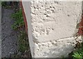
Ordnance Survey Cut Mark
This OS cut mark can be found on No9 Surtees Street, an Art Studio. It marks a point 5.877m above mean sea level.
Image: © Adrian Dust
Taken: 17 Sep 2018
0.09 miles
4
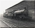
West Hartlepool locomotive shed
Two former NER, Q6 locomotives stand outside in the rain.
Image: © Roger Cornfoot
Taken: Unknown
0.10 miles
5
Hartlepool - former post office on Whitby Street
Image: © Dave Bevis
Taken: 31 May 2014
0.10 miles
6

Hartlepool - house at corner of Scarborough Street
With Exeter Street.
Image: © Dave Bevis
Taken: 31 May 2014
0.14 miles
7
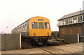
Class 101 DMU British Rail Regional Railways passing over railway crossing in Hartlepool, April 1986.
Image: © Martin Routledge
Taken: Unknown
0.15 miles
8
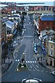
Church Street
Heading directly towards the new apartments and building surrounding the marina. Taken from the top of the tower of Christ Church. In the distance is The Headland.
Image: © Mick Garratt
Taken: 12 Jan 2007
0.15 miles
9

Hartlepool - terrace on Scarborough Street
Image: © Dave Bevis
Taken: 31 May 2014
0.16 miles
10
Ordnance Survey Cut Mark
This OS cut mark can be found on The Athenaeum Club, Church Street . It marks a point 6.255m above mean sea level.
Image: © Adrian Dust
Taken: 17 Sep 2018
0.16 miles