IMAGES TAKEN NEAR TO
Victoria Road, HARTLEPOOL, TS24 4SR
Introduction
This page details the photographs taken nearby to Victoria Road, TS24 4SR by members of the Geograph project.
The Geograph project started in 2005 with the aim of publishing, organising and preserving representative images for every square kilometre of Great Britain, Ireland and the Isle of Man.

There are currently over 7.5m images from over14,400 individuals and you can help contribute to the project by visiting https://www.geograph.org.uk
Image Map
Images are licensed for reuse under creativecommons.org/licenses/by-sa/2.0
Notes
- Clicking on the map will re-center to the selected point.
- The higher the marker number, the further away the image location is from the centre of the postcode.
Image Listing (167 Images Found)
Images are licensed for reuse under creativecommons.org/licenses/by-sa/2.0
Image
Details
Distance
1
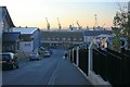
Union Street
Headland Sports Hall on the left and the Victoria Docks in the distance.
Image: © Mick Garratt
Taken: 16 Nov 2007
0.02 miles
2
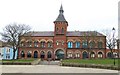
Borough Hall, Hartlepool
The Borough Hall dates from 1865 and was recently refurbished. A public hall with a variety of uses.
Image: © Gordon Hatton
Taken: 18 Mar 2019
0.03 miles
3

Saint Mary's altar
The altar in Saint Mary's Church on the Headland.
Image: © ian malcolmson
Taken: 9 Jun 2010
0.03 miles
4
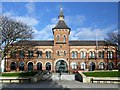
Hartlepool Borough Hall
There is another photograph here Image
The Borough Hall and Market Buildings were opened in 1866 and housed a covered market and the Police Station. The building was designed by C J Adam of Stockton in Italianate style. The central feature is the turreted tower, decorated with a medallion bearing the Borough Arms. It was re-opened after an £800,000 refurbishment.
As the largest public building in Hartlepool, it provides a venue for various entertainment as diverse as The Music and Beer Festival, BBC Question Time, the annual Horticultural Show, North East Model Scale Show and the Hartlepool Chess Congress. Morrissey, The Chippendales and Billy Connolly have also appeared here. Some of the former police cells are now the toilets for people using the Constable's bar. The doors leading to the toilets are the original ones from the prison cells and still feature the original viewing hatches and bars on the inside windows. Upstairs, the old magistrates' court still remains now known as the Croft Room http://www.hartlepoolmail.co.uk/council-services-az/B-is-for-Borough-Hall.4404987.jp
The Headland area of Hartlepool is thought to be one of the most haunted areas in the country and the hall itself is considered as one of the spooky venues http://www.hauntedland.co.uk/investigations/investigations/boroughhall.html
Image: © Andrew Curtis
Taken: 4 Dec 2009
0.03 miles
5
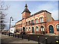
Hartlepool Borough Hall
On the Headland, near St Hilda's Church.
Image: © Robert Graham
Taken: 13 Feb 2012
0.03 miles
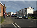
6
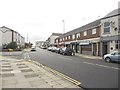
Northgate, Hartlepool
Looking along Northgate. A terraced row of shops is on the right. Union Street appears from the left to meet Northgate at the road junction ahead.
Image: © Graham Robson
Taken: 11 Sep 2018
0.04 miles
7

St Mary's church, Hartlepool
The present Catholic church is rather overshadowed by its older and larger Anglican neighbour.
Image: © Stephen Craven
Taken: 23 Sep 2008
0.04 miles
8
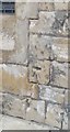
Ordnance Survey 1GL Bolt
This OS Bolt can be found on the SE face of the R.C. Church. It marks a point 14.243m above mean sea level.
Image: © Adrian Dust
Taken: 17 Sep 2018
0.04 miles
9
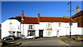
Town house, Middlegate, Hartlepool Headland
Next door to The Cosmo Image
Image: © Andrew Curtis
Taken: 4 Dec 2009
0.05 miles
10
Northgate, Headland
The end of the A1049, the recently-designated England Coast Path traverses the pavement on the left.
Image: © Oliver Dixon
Taken: 19 Nov 2015
0.05 miles