IMAGES TAKEN NEAR TO
Howard Street, HARTLEPOOL, TS24 0DL
Introduction
This page details the photographs taken nearby to Howard Street, TS24 0DL by members of the Geograph project.
The Geograph project started in 2005 with the aim of publishing, organising and preserving representative images for every square kilometre of Great Britain, Ireland and the Isle of Man.

There are currently over 7.5m images from over14,400 individuals and you can help contribute to the project by visiting https://www.geograph.org.uk
Image Map
Images are licensed for reuse under creativecommons.org/licenses/by-sa/2.0
Notes
- Clicking on the map will re-center to the selected point.
- The higher the marker number, the further away the image location is from the centre of the postcode.
Image Listing (30 Images Found)
Images are licensed for reuse under creativecommons.org/licenses/by-sa/2.0
Image
Details
Distance
1
Spion Kop Cemetery Local Nature Reserve
Image: © Mat Fascione
Taken: 26 Aug 2017
0.06 miles
2
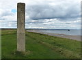
End of Marine Drive, Hartlepool
Looking north to the end of this road which leads along the front of Hartlepool Headland. The stone pillar at the top of the banks marks the site of Spion Kop cemetery, presumably dating it to the time of the Boer War, as this is the name of a battle in that conflict.
Image: © Robert Graham
Taken: 27 Feb 2013
0.06 miles
3
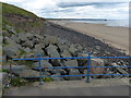
The end of the promenade at North Sands, Hartlepool
Image: © Mat Fascione
Taken: 26 Aug 2017
0.06 miles
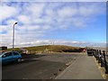
4
The promenade at Throston
On Hartlepool's Headland, looking across the North Sands to the abandoned pier to the old Steetley works
Image: © Graham Hogg
Taken: 4 Nov 2014
0.08 miles
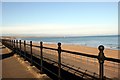
5

The beach looking towards Throston
Almost deserted.
Image: © Jonathan Thacker
Taken: 29 Nov 2012
0.11 miles
6

Flowers next to West View Road in Hartlepool
Image: © Mat Fascione
Taken: 26 Aug 2017
0.11 miles
7
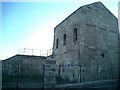
Throston Engine House, Hartlepool.
See http://www.hidden-teesside.co.uk/page/3/
Image: © Richard Atkinson
Taken: 7 Jul 2005
0.12 miles
8
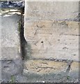
Ordnance Survey Cut Mark
This OS cut mark can be found on the building SW side of Old Cemetery Road. It marks a point 6.733m above mean sea level.
Image: © Adrian Dust
Taken: 17 Sep 2018
0.12 miles
9
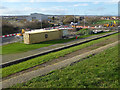
New housing development on West View Road
On the site of the old coal staithes.
Image: © Oliver Dixon
Taken: 19 Nov 2015
0.12 miles
10
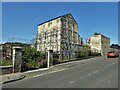
Throston Engine House
On Old Cemetery Road. An historic building formerly used to power lifting of coal wagons on the railway to the staithes at the dock.
Image: © Kevin Waterhouse
Taken: 15 Jun 2023
0.13 miles