IMAGES TAKEN NEAR TO
Lammermuir Road, BILLINGHAM, TS23 2ET
Introduction
This page details the photographs taken nearby to Lammermuir Road, TS23 2ET by members of the Geograph project.
The Geograph project started in 2005 with the aim of publishing, organising and preserving representative images for every square kilometre of Great Britain, Ireland and the Isle of Man.

There are currently over 7.5m images from over14,400 individuals and you can help contribute to the project by visiting https://www.geograph.org.uk
Image Map
Images are licensed for reuse under creativecommons.org/licenses/by-sa/2.0
Notes
- Clicking on the map will re-center to the selected point.
- The higher the marker number, the further away the image location is from the centre of the postcode.
Image Listing (8 Images Found)
Images are licensed for reuse under creativecommons.org/licenses/by-sa/2.0
Image
Details
Distance
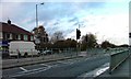
3
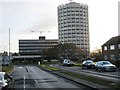
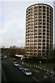
High-rise flats in Billingham
The 'cylindrical' building shown in the right-hand side of this photograph is a distinctive feature of Billingham. The photograph was taken from one of the main approach roads into the town.
Image: © Philip Barker
Taken: 22 Nov 2009
0.14 miles
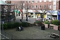
5
The Astronaut
A public house on the edge of the town centre.
Image: © Mick Garratt
Taken: 23 Feb 2007
0.18 miles