IMAGES TAKEN NEAR TO
Skipton Road, BILLINGHAM, TS23 2DS
Introduction
This page details the photographs taken nearby to Skipton Road, TS23 2DS by members of the Geograph project.
The Geograph project started in 2005 with the aim of publishing, organising and preserving representative images for every square kilometre of Great Britain, Ireland and the Isle of Man.

There are currently over 7.5m images from over14,400 individuals and you can help contribute to the project by visiting https://www.geograph.org.uk
Image Map
Images are licensed for reuse under creativecommons.org/licenses/by-sa/2.0
Notes
- Clicking on the map will re-center to the selected point.
- The higher the marker number, the further away the image location is from the centre of the postcode.
Image Listing (8 Images Found)
Images are licensed for reuse under creativecommons.org/licenses/by-sa/2.0
Image
Details
Distance
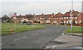
1
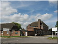
Parkside Day Centre, Melrose Avenue
Image: © Stephen Armstrong
Taken: 6 Jun 2011
0.11 miles
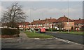
3
Deal Road, Billingham
A turn of Rievaulx Avenue.
Image: © Oliver Dixon
Taken: 6 Jul 2016
0.13 miles
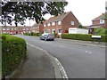
6
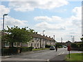
Kenilworth Road
Viewed from Melrose Avenue
Image: © Stephen Armstrong
Taken: 6 Jun 2011
0.16 miles
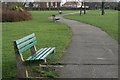
7
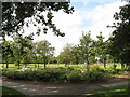
John Whitehead Park
View from the Melrose Avenue / Tintern Avenue entrance.
Image: © Stephen Armstrong
Taken: 6 Jun 2011
0.18 miles
8
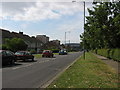
Melrose Avenue
Looking south with John Whitehead Park to the right & The Forum at the far end.
Image: © Stephen Armstrong
Taken: 6 Jun 2011
0.20 miles