IMAGES TAKEN NEAR TO
Woodside, BILLINGHAM, TS22 5SJ
Introduction
This page details the photographs taken nearby to Woodside, TS22 5SJ by members of the Geograph project.
The Geograph project started in 2005 with the aim of publishing, organising and preserving representative images for every square kilometre of Great Britain, Ireland and the Isle of Man.

There are currently over 7.5m images from over14,400 individuals and you can help contribute to the project by visiting https://www.geograph.org.uk
Image Map
Images are licensed for reuse under creativecommons.org/licenses/by-sa/2.0
Notes
- Clicking on the map will re-center to the selected point.
- The higher the marker number, the further away the image location is from the centre of the postcode.
Image Listing (6 Images Found)
Images are licensed for reuse under creativecommons.org/licenses/by-sa/2.0
Image
Details
Distance
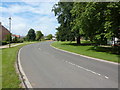
2

Wynyard village cricket ground.
The cricket pitch has been completely built round, one of the roads being appropriately named 'The Oval'. A local informs me that only one or two matches are played here each year.
Image: © Carol Rose
Taken: 15 Apr 2007
0.15 miles
3
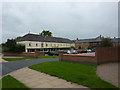
The Village Store, Wynyard Village
Image: © Alexander P Kapp
Taken: 23 Aug 2011
0.17 miles
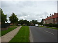
4
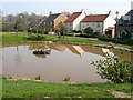
New houses and duckpond, Wynyard village.
These mixed style new houses have been built to replicate the old style houses in the real, old villages in the area.
Image: © Carol Rose
Taken: 15 Apr 2007
0.19 miles
5
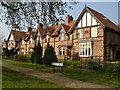
Salters Houses Wynyard village.
These houses were built by the Marquise of Londonderry's Estates in 1900. They are now surrounded by the modern Wynyard village.
Image: © Carol Rose
Taken: 15 Apr 2007
0.22 miles