IMAGES TAKEN NEAR TO
Brambling Grove, BILLINGHAM, TS22 5FX
Introduction
This page details the photographs taken nearby to Brambling Grove, TS22 5FX by members of the Geograph project.
The Geograph project started in 2005 with the aim of publishing, organising and preserving representative images for every square kilometre of Great Britain, Ireland and the Isle of Man.

There are currently over 7.5m images from over14,400 individuals and you can help contribute to the project by visiting https://www.geograph.org.uk
Image Map (Loading...)


Getting Data...Please wait
Leaflet Map data © OpenStreetMap
Images are licensed for reuse under creativecommons.org/licenses/by-sa/2.0
Notes
- Clicking on the map will re-center to the selected point.
- The higher the marker number, the further away the image location is from the centre of the postcode.
Image Listing (4 Images Found)
Images are licensed for reuse under creativecommons.org/licenses/by-sa/2.0
Image
Details
Distance
1
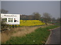
Wynyard Park stretches on.
The A689 is to the right of the picture. The hoarding advertises the benefits of bringing your business to Wynyard Park.
Image: © Carol Rose
Taken: 15 Apr 2007
0.04 miles
2
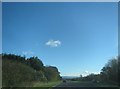
The A689, Coal Lane section, eastwards towards Teeside
Image: © Peter Robinson
Taken: 3 Nov 2013
0.14 miles
4
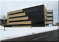
Lion Court Wynyard Park
Occupied by Amec Ltd. as a design and engineering centre
Image: © Peter Robinson
Taken: 26 Dec 2010
0.23 miles