IMAGES TAKEN NEAR TO
Humber Grove, BILLINGHAM, TS22 5EE
Introduction
This page details the photographs taken nearby to Humber Grove, TS22 5EE by members of the Geograph project.
The Geograph project started in 2005 with the aim of publishing, organising and preserving representative images for every square kilometre of Great Britain, Ireland and the Isle of Man.

There are currently over 7.5m images from over14,400 individuals and you can help contribute to the project by visiting https://www.geograph.org.uk
Image Map
Images are licensed for reuse under creativecommons.org/licenses/by-sa/2.0
Notes
- Clicking on the map will re-center to the selected point.
- The higher the marker number, the further away the image location is from the centre of the postcode.
Image Listing (7 Images Found)
Images are licensed for reuse under creativecommons.org/licenses/by-sa/2.0
Image
Details
Distance
3
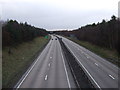
Traffic on the A19(T) trunk road
This photograph shows a 'snapshot' of the traffic flow on the A19(T) road as it skirts through the left-hand side of the grid-square. The picture was taken looking in a north-north-easterly direction towards the A19(T)/A689 road interchange.
Image: © Philip Barker
Taken: 16 Apr 2010
0.17 miles
4
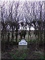
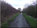
Boundary stone and hedgerow, Wolviston Mill Lane
Image: © JThomas
Taken: 12 Jan 2013
0.19 miles
6
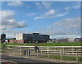
Northfield School and Sports College Billingham
Image: © Peter Robinson
Taken: 21 Oct 2010
0.22 miles