IMAGES TAKEN NEAR TO
Huntsman Drive, MIDDLESBROUGH, TS2 1UE
Introduction
This page details the photographs taken nearby to Huntsman Drive, TS2 1UE by members of the Geograph project.
The Geograph project started in 2005 with the aim of publishing, organising and preserving representative images for every square kilometre of Great Britain, Ireland and the Isle of Man.

There are currently over 7.5m images from over14,400 individuals and you can help contribute to the project by visiting https://www.geograph.org.uk
Image Map
Images are licensed for reuse under creativecommons.org/licenses/by-sa/2.0
Notes
- Clicking on the map will re-center to the selected point.
- The higher the marker number, the further away the image location is from the centre of the postcode.
Image Listing (2 Images Found)
Images are licensed for reuse under creativecommons.org/licenses/by-sa/2.0
Image
Details
Distance
1
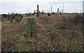
Trig point on desolate land
The trig point (flush bracket number S4863), was known to the OS by the appropriately dismal name, 'Bell's Tip'. It's no longer there having been lost to redevelopment of the site.
Image: © Trevor Littlewood
Taken: 7 Jan 2005
0.09 miles
2
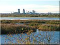
Bird Reserve, Saltholme Marshes
View west towards the petrochemical works at Billingham.
Image: © Mick Garratt
Taken: 25 Nov 2005
0.24 miles