IMAGES TAKEN NEAR TO
Port Clarence Road, MIDDLESBROUGH, TS2 1SY
Introduction
This page details the photographs taken nearby to Port Clarence Road, TS2 1SY by members of the Geograph project.
The Geograph project started in 2005 with the aim of publishing, organising and preserving representative images for every square kilometre of Great Britain, Ireland and the Isle of Man.

There are currently over 7.5m images from over14,400 individuals and you can help contribute to the project by visiting https://www.geograph.org.uk
Image Map
Images are licensed for reuse under creativecommons.org/licenses/by-sa/2.0
Notes
- Clicking on the map will re-center to the selected point.
- The higher the marker number, the further away the image location is from the centre of the postcode.
Image Listing (16 Images Found)
Images are licensed for reuse under creativecommons.org/licenses/by-sa/2.0
Image
Details
Distance
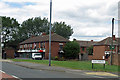
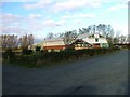
1
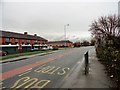
Shops at High Clarence
Row of shops on the housing estate, on the A1046.
Image: © Robert Graham
Taken: 21 Nov 2012
0.06 miles
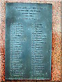
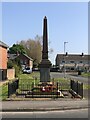
2
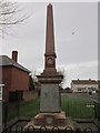
The Haverton Hill and Port Clarence War Memorial
Image: © Ian S
Taken: 3 Feb 2013
0.08 miles
3
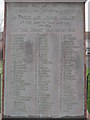
The Haverton Hill and Port Clarence War Memorial
Image: © Ian S
Taken: 3 Feb 2013
0.08 miles
4
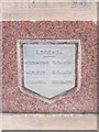
The Haverton Hill and Port Clarence War Memorial
Image: © Ian S
Taken: 3 Feb 2013
0.08 miles
5
The Haverton Hill and Port Clarence War Memorial
Image: © Ian S
Taken: 3 Feb 2013
0.08 miles
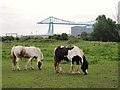
10
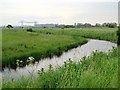
(Part of) RSPB Saltholme Reserve north of Port Clarence
For info about the reserve, see http://www.rspb.org.uk/reserves/guide/s/saltholme/.
Image: © Mike Quinn
Taken: 17 Jun 2013
0.14 miles