IMAGES TAKEN NEAR TO
Pioneering Way, MIDDLESBROUGH, TS2 1DH
Introduction
This page details the photographs taken nearby to Pioneering Way, TS2 1DH by members of the Geograph project.
The Geograph project started in 2005 with the aim of publishing, organising and preserving representative images for every square kilometre of Great Britain, Ireland and the Isle of Man.

There are currently over 7.5m images from over14,400 individuals and you can help contribute to the project by visiting https://www.geograph.org.uk
Image Map
Images are licensed for reuse under creativecommons.org/licenses/by-sa/2.0
Notes
- Clicking on the map will re-center to the selected point.
- The higher the marker number, the further away the image location is from the centre of the postcode.
Image Listing (315 Images Found)
Images are licensed for reuse under creativecommons.org/licenses/by-sa/2.0
Image
Details
Distance
1
Building of the Middlesbrough Pottery in 1831
The Middlesbrough Pottery was the first established industry in Middlesbrough predating iron and steel. It was established in 1831 and Middlesbrough Pottery in today highly collectable. The building which now stands apparently empty. If the proposed development of the area is implemented in full (http://www.teesvalleyregeneration.co.uk/pages/project/project=Middlehaven) then the building will be demolished.
Image: © Mick Garratt
Taken: 9 Nov 2005
0.03 miles
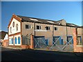
2
New building, Durham Street
The area is undergoing redevelopment and there is currently a large area of former residential and industrial land under grass. This is one of the first new buildings to go up.
Image: © Richard Webb
Taken: 10 Aug 2016
0.03 miles
3
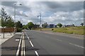
Durham Street
The former town centre, now undergoing redevelopment.
Image: © Richard Webb
Taken: 10 Aug 2016
0.03 miles
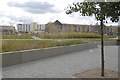
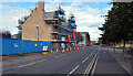
4

Park beside Durham Street
Recently redeveloped area on the north side of Middlesbrough Station, including a piece of public art. But the old Captain Cook public house is still standing although it has been closed for at least four years (see Image).
Image: © Oliver Dixon
Taken: 21 Mar 2017
0.04 miles
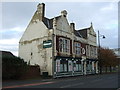
5
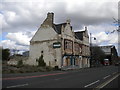
The Captain Cook, Durham Street, Middlesbrough
A disused pub in a part of the town that has largely been razed to the ground.
Image: © Richard Vince
Taken: 10 Apr 2017
0.04 miles
6
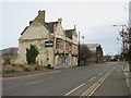
Derelict pub, Middlesbrough
The Captain Cook pub in Middlesbrough. The pub stands derelict and forlorn, having closed in 2010.
Image: © Malc McDonald
Taken: 3 Mar 2019
0.04 miles
8
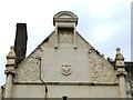
Decorated gable on The Captain Cook, Cleveland Street (A178), TS1
See Image
Image: © Mike Quinn
Taken: 17 Jun 2013
0.04 miles
9
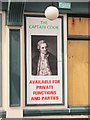
Sign on The Captain Cook, Cleveland Street (A178), TS1
See Image
Image: © Mike Quinn
Taken: 17 Jun 2013
0.04 miles