IMAGES TAKEN NEAR TO
Moorside Crescent, STOCKTON-ON-TEES, TS21 4DJ
Introduction
This page details the photographs taken nearby to Moorside Crescent, TS21 4DJ by members of the Geograph project.
The Geograph project started in 2005 with the aim of publishing, organising and preserving representative images for every square kilometre of Great Britain, Ireland and the Isle of Man.

There are currently over 7.5m images from over14,400 individuals and you can help contribute to the project by visiting https://www.geograph.org.uk
Image Map
Images are licensed for reuse under creativecommons.org/licenses/by-sa/2.0
Notes
- Clicking on the map will re-center to the selected point.
- The higher the marker number, the further away the image location is from the centre of the postcode.
Image Listing (18 Images Found)
Images are licensed for reuse under creativecommons.org/licenses/by-sa/2.0
Image
Details
Distance
2
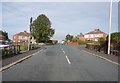
Oakdene Road, Fishburn
Oakdene Road in the village of Fishburn, in County Durham.
Image: © Malc McDonald
Taken: 20 Apr 2019
0.05 miles
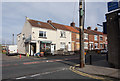
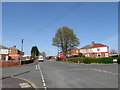
3
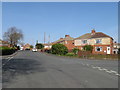
Moorside Crescent, Fishburn
Moorside Crescent is a residential road in the village of Fishburn, in County Durham.
Image: © Malc McDonald
Taken: 20 Apr 2019
0.06 miles
4
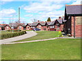
Fishburn Aged Miners Homes
Very small bungalows built for retired coalminers are to be found throughout County Durham. This is a particularly neat and tidy row of such homes.
Image: © Oliver Dixon
Taken: 10 Apr 2006
0.06 miles
5
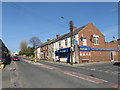
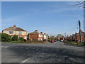
Salter's Lane, Fishburn
Salter's Lane is the main road through the village of Fishburn, in County Durham. On the street corner is a local shop.
Image: © Malc McDonald
Taken: 20 Apr 2019
0.08 miles
7
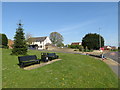
Benches on the village green, Fishburn
Benches on the village green in Fishburn, in County Durham.
Image: © Malc McDonald
Taken: 20 Apr 2019
0.14 miles
8
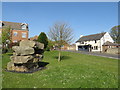
Miners' Memorial, Fishburn
The village of Fishburn in County Durham used to have a colliery employing more than 1,000 men. The colliery closed in 1973.
In 2003, a memorial to Fishburn's miners was unveiled on the village green. The memorial is in the foreground to the left of this image, while The Beehive pub is in the background to the right.
Image: © Malc McDonald
Taken: 20 Apr 2019
0.15 miles
9
Moorside Crescent, Fishburn
Moorside Crescent is a residential road in the village of Fishburn, in County Durham.
Image: © Malc McDonald
Taken: 20 Apr 2019
0.15 miles
10
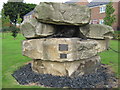
Fishburn Green Memorial
In this former mining village in County Durham, dedicated to the memory of all the coalminers of Fishburn
Image: © Peter Robinson
Taken: 8 Jul 2009
0.15 miles