IMAGES TAKEN NEAR TO
Sedgefield, STOCKTON-ON-TEES, TS21 3EN
Introduction
This page details the photographs taken nearby to TS21 3EN by members of the Geograph project.
The Geograph project started in 2005 with the aim of publishing, organising and preserving representative images for every square kilometre of Great Britain, Ireland and the Isle of Man.

There are currently over 7.5m images from over14,400 individuals and you can help contribute to the project by visiting https://www.geograph.org.uk
Image Map (Loading...)


Getting Data...Please wait
Leaflet Map data © OpenStreetMap
Images are licensed for reuse under creativecommons.org/licenses/by-sa/2.0
Notes
- Clicking on the map will re-center to the selected point.
- The higher the marker number, the further away the image location is from the centre of the postcode.
Image Listing (3 Images Found)
Images are licensed for reuse under creativecommons.org/licenses/by-sa/2.0
Image
Details
Distance
1
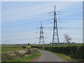
Pylons near Sedgefield
Electricity pylons looming large over Butterwick Road, in the County Durham countryside. Further in the distance, a wind farm is visible.
Image: © Malc McDonald
Taken: 20 Apr 2019
0.13 miles
2
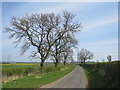
Butterwick Road, near Sedgefield
Butterwick Road is a minor road through countryside east of Sedgefield, in County Durham.
Image: © Malc McDonald
Taken: 20 Apr 2019
0.17 miles
3
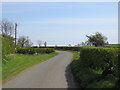
Butterwick Road, near Sedgefield
Butterwick Road is a minor road through countryside to the east of Sedgefield, in County Durham.
Image: © Malc McDonald
Taken: 20 Apr 2019
0.24 miles