IMAGES TAKEN NEAR TO
West End, STOCKTON-ON-TEES, TS21 2BS
Introduction
This page details the photographs taken nearby to West End, TS21 2BS by members of the Geograph project.
The Geograph project started in 2005 with the aim of publishing, organising and preserving representative images for every square kilometre of Great Britain, Ireland and the Isle of Man.

There are currently over 7.5m images from over14,400 individuals and you can help contribute to the project by visiting https://www.geograph.org.uk
Image Map
Images are licensed for reuse under creativecommons.org/licenses/by-sa/2.0
Notes
- Clicking on the map will re-center to the selected point.
- The higher the marker number, the further away the image location is from the centre of the postcode.
Image Listing (114 Images Found)
Images are licensed for reuse under creativecommons.org/licenses/by-sa/2.0
Image
Details
Distance
1
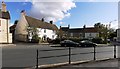
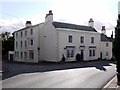
No 10, West End, Sedgefield
The rough-cast whitewashed house, in the angle where West End turns to run westwards, was originally built as three separate cottages in the early C17th. By 1827 it had become a large single house known as Rose Cottage. It is now called Badgers Green. There is a brick segmented arch incorporated in the right hand half of the house, which was the drive for carriages http://www.sedgefield.net/hertrail/badgreen.html
List entry Number: 1121491 https://www.historicengland.org.uk/listing/the-list/list-entry/1121491
Image: © Andrew Curtis
Taken: 7 Oct 2011
0.00 miles
3
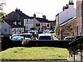
West End from the Manor House, Sedgefield
Image is visible on the distant bend.
Image: © Andrew Curtis
Taken: 7 Oct 2011
0.02 miles
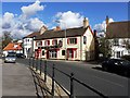
4
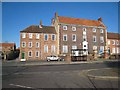
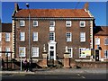
Sedgefield House, West End, Sedgefield
Sedgefield House is an attractive grade II listed building in the Regency style on the corner of West End and Spring Lane. It dates from the early C19th.
https://www.historicengland.org.uk/listing/the-list/list-entry/1310712
Image: © Andrew Curtis
Taken: 7 Oct 2011
0.04 miles
5
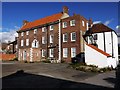
Sedgefield Manor
This magnificent building (the one on the right) was built in 1707 but was never occupied by the Lord of the Manor (who happened to also be the Bishop of Durham). The house was subsequently used as a school, as the offices of the former Sedgefield Rural District Council and as a Magistrate's Court.
Image: © Oliver Dixon
Taken: 4 Apr 2007
0.04 miles
6
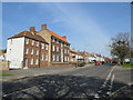
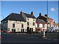
West End, Sedgefield
West End in the town of Sedgefield, in County Durham.
Image: © Malc McDonald
Taken: 20 Apr 2019
0.06 miles
7
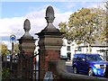
Gate piers outside the Manor House, West End, Sedgefield
The gate piers are crowned by pineapple finials which apparently are not their best bits which may include their remnants of an original moulded stone base, and support entablature with pulvinated frieze and projecting cornice.
National Heritage List for England Entry Number: 1160119 https://www.historicengland.org.uk/listing/the-list/list-entry/1160119
Image: © Andrew Curtis
Taken: 7 Oct 2011
0.07 miles
8
The Manor House (rear elevation), West End, Sedgefield
For description see Image
Image: © Andrew Curtis
Taken: 7 Oct 2011
0.07 miles
9
The Manor House, West End, Sedgefield
The Manor House looks east across The Green Image It is an impressive three-storey building and was part of the Hardwick Estate until 1923. It is a fine example of Queen Anne architecture and was built in 1707 (shown by an inscription on the sundial attached to the front of the house Image). The building was used as a Boarding School in the 1820s, the Rural District Council Offices, the Magistrate's Court House, and as offices. It has been carefully restored and is currently to let. The rear of the house has a splendid staircase window and also shows signs of early alteration Image
http://www.sedgefield.net/hertrail/manor.html
Image: © Andrew Curtis
Taken: 7 Oct 2011
0.07 miles