IMAGES TAKEN NEAR TO
High Street, STOCKTON-ON-TEES, TS21 2AU
Introduction
This page details the photographs taken nearby to High Street, TS21 2AU by members of the Geograph project.
The Geograph project started in 2005 with the aim of publishing, organising and preserving representative images for every square kilometre of Great Britain, Ireland and the Isle of Man.

There are currently over 7.5m images from over14,400 individuals and you can help contribute to the project by visiting https://www.geograph.org.uk
Image Map
Images are licensed for reuse under creativecommons.org/licenses/by-sa/2.0
Notes
- Clicking on the map will re-center to the selected point.
- The higher the marker number, the further away the image location is from the centre of the postcode.
Image Listing (124 Images Found)
Images are licensed for reuse under creativecommons.org/licenses/by-sa/2.0
Image
Details
Distance
1
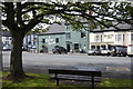
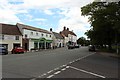
Businesses on the north side of High Street
The Corner House and Tickety Boo: both are concerns in the village of Sedgefield. The Corner House is a restaurant and bar, Tickety Boo, a sweet and gift shop.
(Note: tickety boo is a rather old-fashioned term meaning that everything is satisfactory.)
Image: © Trevor Littlewood
Taken: 24 Jul 2019
0.01 miles
2
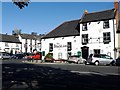
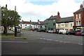
The Black Lion, High Street, Sedgefield
The Black Lion is another of the old inns in Sedgefield, the left part probably built in the early C18th. The property has a former stable wing at the rear and is a grade II listed building.
National Heritage List for England Entry Number: 1322836 https://www.historicengland.org.uk/listing/the-list/list-entry/1322836
There is an earlier photo here Image
To the right, across the road on North End, is the Hardwick Arms Hotel, currently undergoing work on its roof Image
Image: © Andrew Curtis
Taken: 7 Oct 2011
0.02 miles
4
Black Lion Sedgefield
View across the main street to the Black Lion pub.
Image: © Robert Graham
Taken: 29 Mar 2011
0.02 miles
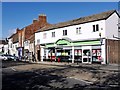
6
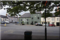
Sedgefield town centre
The middle of the small town of Sedgefield. A number of independent shops are located on the high street in addition to a Co-op supermarket.
Image: © Graham Robson
Taken: 6 Jul 2019
0.02 miles
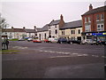
7
High Street, Sedgefield
The western end of High Street in Sedgefield.
Image: © Graham Robson
Taken: 6 Jul 2019
0.02 miles
8
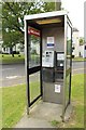
Broken telephone, High Street, Sedgefield
The telephone box on Sedgefield High Street containing a broken telephone (the handset is missing, presumed vandalised). A notice above the telephone indicates that the box has been slated for removal.
Image: © Graham Robson
Taken: 6 Jul 2019
0.02 miles
9
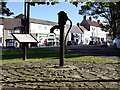
Water pump & High Street, Sedgefield
The water pump on Sedgefield green opposite the Black Lion public house is the start of the Sedgefield heritage trail. According to the trail leaflet, Sedgefield used to be renowned for the quality of its water and was once referred to as the 'Montpellier of the North'.
A plaque describing the heritage trail is on the left and details can be seen online http://www.sedgefield.net/hertrail/htindex.html
Image: © Andrew Curtis
Taken: 7 Oct 2011
0.03 miles
10
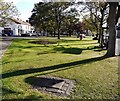
Sedgefield Bull Ring, Town Green
On the corner of the Green opposite the Black Lion pub, the ring was probably used by farmers tying up their bulls on market day. It is also traditionally the start and finish point of the Shrove Tuesday Ball Game Image
Image: © Andrew Curtis
Taken: 7 Oct 2011
0.03 miles