IMAGES TAKEN NEAR TO
South View, STOCKTON-ON-TEES, TS21 2AA
Introduction
This page details the photographs taken nearby to South View, TS21 2AA by members of the Geograph project.
The Geograph project started in 2005 with the aim of publishing, organising and preserving representative images for every square kilometre of Great Britain, Ireland and the Isle of Man.

There are currently over 7.5m images from over14,400 individuals and you can help contribute to the project by visiting https://www.geograph.org.uk
Image Map (Loading...)


Getting Data...Please wait
Leaflet Map data © OpenStreetMap
Images are licensed for reuse under creativecommons.org/licenses/by-sa/2.0
Notes
- Clicking on the map will re-center to the selected point.
- The higher the marker number, the further away the image location is from the centre of the postcode.
Image Listing (121 Images Found)
Images are licensed for reuse under creativecommons.org/licenses/by-sa/2.0
Image
Details
Distance
1
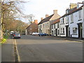
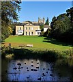
Rectory Row Sedgefield County Durham
Image: © Peter Robinson
Taken: 18 Nov 2010
0.02 miles
2
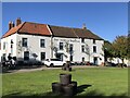
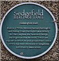
Ceddesfield Hall, Rectory Road, Sedgefield
The former Rectory was built in 1793 by Admiral Samuel Barrington and Bishop Shute Barrington for their nephew, the Reverend George Barrington, so that he could live 'in the manner to which he was accustomed'. It was converted in 1973 by the local Community Association for community use and renamed Ceddesfield Hall. The medieval rectory here which burnt down in 1793 was reputedly haunted by 'The Pickled Parson' who, some say, still resides in a lost tunnel leading from St Edmund's Church to the Rectory http://www.sedgefield.net/hertrail/ceddes.html
The name, 'Ceddesfeld', was the old name for Sedgefield recorded in documentary sources in the years 915 and 1050. It is Anglo-Saxon in origin and may simply mean "Cedds' Field" or alternatively may reflect the nature of the surrounding area which, before land improvement, was damp and marshy, and often referred to as 'sedge'.
National Heritage List for England Entry Number: 1160001 https://www.historicengland.org.uk/listing/the-list/list-entry/1160001
Image: © Andrew Curtis
Taken: 7 Oct 2011
0.03 miles
3
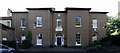
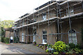
Ceddesfield Hall, Rectory Road, Sedgefield
See here for description Image
Image: © Andrew Curtis
Taken: 7 Oct 2011
0.03 miles
4
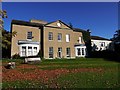
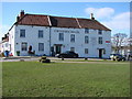
Ceddesfield Hall from the pond
The grounds of the former rectory Image were laid out to a design by Joseph Spence in 1756 as a public park, and now maintained by Sedgefield Town Council. The pond may have been originally constructed as a medieval fish pond.
There is a full description on the Parks & Gardens UK website here https://www.parksandgardens.org/places/ceddesfeld-hall-gardens
Image: © Andrew Curtis
Taken: 7 Oct 2011
0.03 miles
8
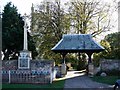
War Memorial, lytch-gate and St Edmund's Church, Sedgefield
The lytch gate was erected in 1906 as a memorial to a Mr & Mrs Thompson, old residents of the town, at the behest of their son who was an alderman.
The War Memorial is described here Image
Image: © Andrew Curtis
Taken: 7 Oct 2011
0.06 miles
9
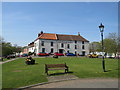
Green in Sedgefield
A green in Sedgefield, in County Durham. In the background is a pub, The Pickled Parson of Sedgefield. The Pickled Parson is the subject of local folklore. Church Times has more information: https://www.churchtimes.co.uk/articles/2017/19-may/news/uk/pickled-parson-promotes-parish
Image: © Malc McDonald
Taken: 20 Apr 2019
0.06 miles