IMAGES TAKEN NEAR TO
Parkside, STOCKTON-ON-TEES, TS21 1DE
Introduction
This page details the photographs taken nearby to Parkside, TS21 1DE by members of the Geograph project.
The Geograph project started in 2005 with the aim of publishing, organising and preserving representative images for every square kilometre of Great Britain, Ireland and the Isle of Man.

There are currently over 7.5m images from over14,400 individuals and you can help contribute to the project by visiting https://www.geograph.org.uk
Image Map (17 Images)


Getting Data...Please wait
Leaflet Map data © OpenStreetMap
Images are licensed for reuse under creativecommons.org/licenses/by-sa/2.0
Notes
- Clicking on the map will re-center to the selected point.
- The higher the marker number, the further away the image location is from the centre of the postcode.
Image Listing (17 Images Found)
Images are licensed for reuse under creativecommons.org/licenses/by-sa/2.0
Image
Details
Distance
1

Old Milestone by the former A66, Darlington Road, Longnewton
Carved stone post by the UC road (was A66), in parish of LONGNEWTON (STOCKTON ON TEES District), roadside verge, on North side of road. D/S stone, erected by the Stockton & Barnard Castle turnpike trust in the 19th century.
Inscription reads:-
: S / 5 : : D / 6 :
Milestone Society National ID: DU_DAST06.
Image: © IA Davison
Taken: 12 Aug 2011
0.03 miles
2

Old Milestone by road (was A66), Darlington Road, Longnewton
The Milestone is located roadside verge on the North of the road. Parish of Longnewton (Stockton-on-Tees District). Carved stone post, D/S stone design, erected by the Stockton & Barnard Castle turnpike trust in the 19th Century. An earlier photograph can be found here: https://www.geograph.org.uk/photo/5624063
Inscription reads:-
S / 5 / : : D / 6
Milestone Society National ID: DU_DAST06
Image: © Hilary Jones
Taken: 1 Jan 2023
0.03 miles

4

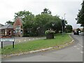
The Green, Long Newton
A breezy day in March.
Image: © Andrew Jones
Taken: 28 Mar 2008
0.11 miles
5
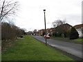
The Willow Chase, Long Newton
The area to the left is the Willow Chase Community Woodland. The area is owned by the village and managed by the Parish Council.
Image: © Andrew Jones
Taken: 28 Mar 2008
0.14 miles
6
The Wilson Centre now the Village Hall Longnewton
Built as a church institute in 1886 and named after its benefactor Rev Wilson. It is now leased from the diocese as a village hall. At the junction of Darlington Road and Long Newton Lane
Image: © Martin Dawes
Taken: 31 Jul 2021
0.16 miles
7

The Newton Centre, Longnewton
Village hall and venue.
The building was built in 1886 with money bequeathed by Rev. J. Wilson, the vicar of St Mary’s Church, Long Newton, as a church institute and for the education and instruction of the inhabitants of Long Newton
Image: © JThomas
Taken: 5 Jan 2013
0.16 miles
8

St Mary's Longnewton
The churchyard and west porch.
Image: © Nigel Mykura
Taken: 24 Aug 2008
0.17 miles

