IMAGES TAKEN NEAR TO
Durham Lane, STOCKTON-ON-TEES, TS21 1AE
Introduction
This page details the photographs taken nearby to Durham Lane, TS21 1AE by members of the Geograph project.
The Geograph project started in 2005 with the aim of publishing, organising and preserving representative images for every square kilometre of Great Britain, Ireland and the Isle of Man.

There are currently over 7.5m images from over14,400 individuals and you can help contribute to the project by visiting https://www.geograph.org.uk
Image Map
Images are licensed for reuse under creativecommons.org/licenses/by-sa/2.0
Notes
- Clicking on the map will re-center to the selected point.
- The higher the marker number, the further away the image location is from the centre of the postcode.
Image Listing (4 Images Found)
Images are licensed for reuse under creativecommons.org/licenses/by-sa/2.0
Image
Details
Distance
2
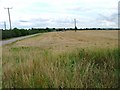
Stubble Field, Durham Lane
Looking east from Durham Lane towards Burnhope Farm. There are plans to develop this land. The track is not shown on the OS:25000 map.
Image: © Mick Garratt
Taken: 1 Sep 2005
0.08 miles
3
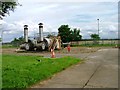
Gas Installation
Photographed from the west on Durham Road
Image: © Mick Garratt
Taken: 1 Sep 2005
0.12 miles