IMAGES TAKEN NEAR TO
Fairview Gardens, STOCKTON-ON-TEES, TS20 1UA
Introduction
This page details the photographs taken nearby to Fairview Gardens, TS20 1UA by members of the Geograph project.
The Geograph project started in 2005 with the aim of publishing, organising and preserving representative images for every square kilometre of Great Britain, Ireland and the Isle of Man.

There are currently over 7.5m images from over14,400 individuals and you can help contribute to the project by visiting https://www.geograph.org.uk
Image Map
Images are licensed for reuse under creativecommons.org/licenses/by-sa/2.0
Notes
- Clicking on the map will re-center to the selected point.
- The higher the marker number, the further away the image location is from the centre of the postcode.
Image Listing (4 Images Found)
Images are licensed for reuse under creativecommons.org/licenses/by-sa/2.0
Image
Details
Distance
1
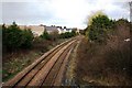
Railway tracks near Norton West Junction
This photograph shows a view of the railway tracks that run between Stockton-on-Tees (behind the photographer) and Billingham. The picture was taken from the road bridge on the B1274 which passes over the railway. The viewing direction was to the north-north-east - looking towards Brookdale Farm.
Image: © Philip Barker
Taken: 3 Apr 2010
0.05 miles
3
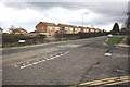
Road junction on Junction Road
This photograph shows a view of the road junction at the intersection of Glebe Road with the B1274 (Junction Road) near The Cleveland Nuffield Hospital (behind the photographer). The picture was taken looking in an east-north-easterly direction towards Billingham.
Image: © Philip Barker
Taken: 3 Apr 2010
0.11 miles
4
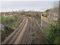
Norton Junction railway station (site), County Durham
Believed to have been opened around 1836 by the Clarence Railway on its line from Stockton to Coxhoe via Ferryside, this station closed in 1877 when it was replaced by a station at Norton (see Image]) around 1km further east on the line from Stockton to Hartlepool.
View north west towards Redmarshall and Ferryside. The original station buildings still stood to the right of the track as late as the 1960s (see https://picturestocktonarchive.wordpress.com/2003/07/01/norton-old-station-junction/ )
Image: © Nigel Thompson
Taken: 1 Jan 2015
0.12 miles