IMAGES TAKEN NEAR TO
Marmaduke Place, STOCKTON-ON-TEES, TS20 1DY
Introduction
This page details the photographs taken nearby to Marmaduke Place, TS20 1DY by members of the Geograph project.
The Geograph project started in 2005 with the aim of publishing, organising and preserving representative images for every square kilometre of Great Britain, Ireland and the Isle of Man.

There are currently over 7.5m images from over14,400 individuals and you can help contribute to the project by visiting https://www.geograph.org.uk
Image Map
Images are licensed for reuse under creativecommons.org/licenses/by-sa/2.0
Notes
- Clicking on the map will re-center to the selected point.
- The higher the marker number, the further away the image location is from the centre of the postcode.
Image Listing (36 Images Found)
Images are licensed for reuse under creativecommons.org/licenses/by-sa/2.0
Image
Details
Distance
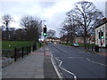
1
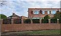
Norton, 30 The Green
There is a benchmark cut into the front left of this corner house which faces onto the village green.
Image: © Mel Towler
Taken: 19 Feb 2022
0.05 miles
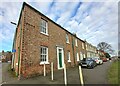
2

Norton, 30 The Green
The benchmark is cut into the front of the house which faces onto the village green.
Image: © Mel Towler
Taken: 19 Feb 2022
0.05 miles
3
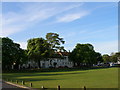
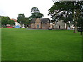
Norton Hall from across Norton Green
Norton Hall is now converted into wonderful apartments- imagine having the ballroom as part of your flat! Before this the building was used by ICI to wine and dine guests.
Image: © Carol Rose
Taken: 25 Apr 2007
0.05 miles

5
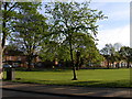
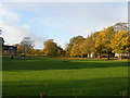
Looking across Norton Green to Red House School
Norton Green is very large and has seven roads cutting through it.
Image: © Carol Rose
Taken: 25 Apr 2007
0.07 miles
6
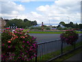
Floral Roundabout on the Stockton Ringroad at Norton
Image: © Ian Barton
Taken: 16 Aug 2008
0.07 miles
9
Norton, Mill Lane
According to the OS benchmark database there was a mark cut into a wall at this location. Today, there is a new property with a new brick wall. The benchmark has been destroyed.
Image: © Mel Towler
Taken: 19 Feb 2022
0.08 miles