IMAGES TAKEN NEAR TO
Rothwell Crescent, STOCKTON-ON-TEES, TS19 9AG
Introduction
This page details the photographs taken nearby to Rothwell Crescent, TS19 9AG by members of the Geograph project.
The Geograph project started in 2005 with the aim of publishing, organising and preserving representative images for every square kilometre of Great Britain, Ireland and the Isle of Man.

There are currently over 7.5m images from over14,400 individuals and you can help contribute to the project by visiting https://www.geograph.org.uk
Image Map
Images are licensed for reuse under creativecommons.org/licenses/by-sa/2.0
Notes
- Clicking on the map will re-center to the selected point.
- The higher the marker number, the further away the image location is from the centre of the postcode.
Image Listing (10 Images Found)
Images are licensed for reuse under creativecommons.org/licenses/by-sa/2.0
Image
Details
Distance
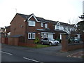
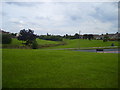
1
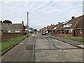
Rothwell Crescent, Roseworth, Stockton
Image: © David Robinson
Taken: 18 Sep 2021
0.06 miles
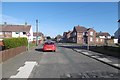
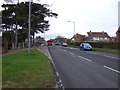
3
Ragpath Lane
The area east of Durham Road was urban on the 1953 1:25,000 map but has since been redeveloped with a different road pattern, including Ragpath Lane which is not on that map.
Image: © Richard Webb
Taken: 10 Aug 2016
0.07 miles
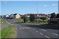
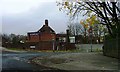
7
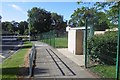
Ragpath Lane
Passing St Gregory's Catholic Academy. (A primary school)
Image: © Richard Webb
Taken: 10 Aug 2016
0.10 miles
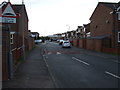
8
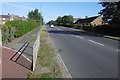
Durham Road, Stockton
A cycle path emerges from the left.
Image: © Richard Webb
Taken: 10 Aug 2016
0.11 miles
10
Darlington Lane/Ragpath Lane Junction, Ragworth
Image: © Mick Garratt
Taken: 22 Nov 2006
0.16 miles