IMAGES TAKEN NEAR TO
Middlefield Road, STOCKTON-ON-TEES, TS19 8XN
Introduction
This page details the photographs taken nearby to Middlefield Road, TS19 8XN by members of the Geograph project.
The Geograph project started in 2005 with the aim of publishing, organising and preserving representative images for every square kilometre of Great Britain, Ireland and the Isle of Man.

There are currently over 7.5m images from over14,400 individuals and you can help contribute to the project by visiting https://www.geograph.org.uk
Image Map (Loading...)


Getting Data...Please wait
Leaflet Map data © OpenStreetMap
Images are licensed for reuse under creativecommons.org/licenses/by-sa/2.0
Notes
- Clicking on the map will re-center to the selected point.
- The higher the marker number, the further away the image location is from the centre of the postcode.
Image Listing (5 Images Found)
Images are licensed for reuse under creativecommons.org/licenses/by-sa/2.0
Image
Details
Distance
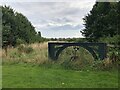
1
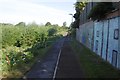
Path passing Butterwick Hospice
Hardwick Dene and Elmtree Woods Nature Reserve on the left.
Image: © Richard Webb
Taken: 10 Aug 2016
0.04 miles
2
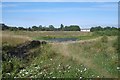
Hardwick Dene and Elmtree Woods Nature Reserve
Near the site of High Newham Farm, a wetland area.
Image: © Richard Webb
Taken: 10 Aug 2016
0.06 miles
3
Overgrown Entrance to Nature Reserve
Gated entrance that doesn't appear to see a lot of use at the north end of Hardwick Dene & Elm Tree Woods Nature Reserve. The reserve lies within urban Stockton, behind the site of the General Hospital.
Image: © David Robinson
Taken: 18 Sep 2021
0.16 miles