IMAGES TAKEN NEAR TO
Cockerton Walk, STOCKTON-ON-TEES, TS19 8QU
Introduction
This page details the photographs taken nearby to Cockerton Walk, TS19 8QU by members of the Geograph project.
The Geograph project started in 2005 with the aim of publishing, organising and preserving representative images for every square kilometre of Great Britain, Ireland and the Isle of Man.

There are currently over 7.5m images from over14,400 individuals and you can help contribute to the project by visiting https://www.geograph.org.uk
Image Map (Loading...)


Getting Data...Please wait
Leaflet Map data © OpenStreetMap
Images are licensed for reuse under creativecommons.org/licenses/by-sa/2.0
Notes
- Clicking on the map will re-center to the selected point.
- The higher the marker number, the further away the image location is from the centre of the postcode.
Image Listing (7 Images Found)
Images are licensed for reuse under creativecommons.org/licenses/by-sa/2.0
Image
Details
Distance
1
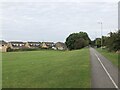
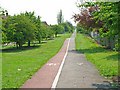
Pedestrian & Cycle Route
Part of the National Cycle Route 1, this stretch of former railway line was an early example of electrification in Britain. The route was part of the Shildon - Newport (Middlesbrough) line that was electrified by NER in 1915 using 1500 V DC overhead. The electrification was removed in 1935, reduced coal traffic making renewal / upgrade uneconomic.
Image: © David Robinson
Taken: 18 Sep 2021
0.14 miles
2
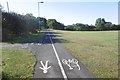
Path, Stockton
Really too narrow to split in two like this. There is a vast area of mown grass on the right. The 1953 1:25,000 map shows farmland on either side of the railway.
Image: © Richard Webb
Taken: 10 Aug 2016
0.15 miles
3
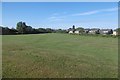
Mown area, Bishopsgarth
Farmland on the 1953 1:25,000 map.
Image: © Richard Webb
Taken: 10 Aug 2016
0.16 miles
4
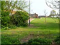
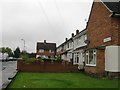
Cawcrook Walk, off Tithebarn Road, Stockton-on-Tees
In the Hardwick district of town. Plenty of green space amongst the houses.
Image: © Oliver Dixon
Taken: 9 May 2006
0.18 miles
5
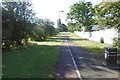
Cycle path, Stockton-on-Tees
Straight as an arrow this cycle path runs along the line of an old railway, which is a southern extension of the Castle Eden Walkway.
Image: © Oliver Dixon
Taken: 9 May 2006
0.22 miles
7
Site of the Stockton and Castle Eden Branch
Now in urban Stockton, the railway trackbed is used as path. This is the start of over 30km of urban riding during which the half (if lucky) of the path for bikes kept swapping over.
Image: © Richard Webb
Taken: 10 Aug 2016
0.25 miles