IMAGES TAKEN NEAR TO
High Newham Road, STOCKTON-ON-TEES, TS19 8NG
Introduction
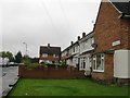
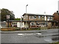
This page details the photographs taken nearby to High Newham Road, TS19 8NG by members of the Geograph project.
The Geograph project started in 2005 with the aim of publishing, organising and preserving representative images for every square kilometre of Great Britain, Ireland and the Isle of Man.

There are currently over 7.5m images from over14,400 individuals and you can help contribute to the project by visiting https://www.geograph.org.uk
Image Map
Images are licensed for reuse under creativecommons.org/licenses/by-sa/2.0
Notes
- Clicking on the map will re-center to the selected point.
- The higher the marker number, the further away the image location is from the centre of the postcode.
Image Listing (3 Images Found)
Images are licensed for reuse under creativecommons.org/licenses/by-sa/2.0
Image
Details
Distance
3
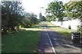
Site of the Stockton and Castle Eden Branch
Now in urban Stockton, the railway trackbed is used as path. This is the start of over 30km of urban riding during which the half (if lucky) of the path for bikes kept swapping over.
Image: © Richard Webb
Taken: 10 Aug 2016
0.25 miles