IMAGES TAKEN NEAR TO
Durham Road, STOCKTON-ON-TEES, TS19 8HH
Introduction
This page details the photographs taken nearby to Durham Road, TS19 8HH by members of the Geograph project.
The Geograph project started in 2005 with the aim of publishing, organising and preserving representative images for every square kilometre of Great Britain, Ireland and the Isle of Man.

There are currently over 7.5m images from over14,400 individuals and you can help contribute to the project by visiting https://www.geograph.org.uk
Image Map
Images are licensed for reuse under creativecommons.org/licenses/by-sa/2.0
Notes
- Clicking on the map will re-center to the selected point.
- The higher the marker number, the further away the image location is from the centre of the postcode.
Image Listing (11 Images Found)
Images are licensed for reuse under creativecommons.org/licenses/by-sa/2.0
Image
Details
Distance
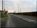
4
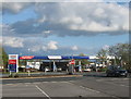
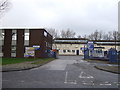
Tesco filling station, Durham Road in Stockton-on-Tees
Image: © Peter Robinson
Taken: 12 May 2012
0.08 miles
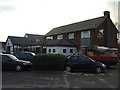
7
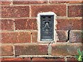
Norton, 89 Renvyle Avenue
The OS Flush Bracket, S8808, is embedded into the south west facing wall of the private house.
Image: © Mel Towler
Taken: 19 Feb 2022
0.11 miles
8
Norton, 89 Renvyle Avenue
The OS Flush Bracket, S8808, is embedded into the south west facing wall of the private house. It can be seen at the bottom right of the gable end.
Image: © Mel Towler
Taken: 19 Feb 2022
0.11 miles
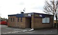
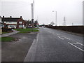
9
Entrance to Builder's Yard
Off Junction Road.
Image: © JThomas
Taken: 12 Jan 2013
0.12 miles