IMAGES TAKEN NEAR TO
Norwich Avenue, STOCKTON-ON-TEES, TS19 0XD
Introduction
This page details the photographs taken nearby to Norwich Avenue, TS19 0XD by members of the Geograph project.
The Geograph project started in 2005 with the aim of publishing, organising and preserving representative images for every square kilometre of Great Britain, Ireland and the Isle of Man.

There are currently over 7.5m images from over14,400 individuals and you can help contribute to the project by visiting https://www.geograph.org.uk
Image Map
Images are licensed for reuse under creativecommons.org/licenses/by-sa/2.0
Notes
- Clicking on the map will re-center to the selected point.
- The higher the marker number, the further away the image location is from the centre of the postcode.
Image Listing (4 Images Found)
Images are licensed for reuse under creativecommons.org/licenses/by-sa/2.0
Image
Details
Distance
3
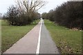
Cycleway and walkway near Elm Tree
This photograph shows a view of the cycleway and walkway that runs parallel to Darlington Lane in the Elm Tree area of Stockton-on-Tees. The picture was taken looking in an easterly direction towards Newham Grange Park.
Image: © Philip Barker
Taken: 13 Mar 2010
0.21 miles
4
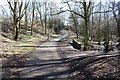
Cycleway and walkway from near Elm Tree
This photograph shows a view of a section of a dismantled railway track that has been converted into a cycleway and walkway. The picture was taken from near Darlington Back Lane looking in a north-north-westerly direction towards Letch Lane.
Image: © Philip Barker
Taken: 11 Mar 2010
0.21 miles