IMAGES TAKEN NEAR TO
Wrensfield Road, STOCKTON-ON-TEES, TS19 0AT
Introduction
This page details the photographs taken nearby to Wrensfield Road, TS19 0AT by members of the Geograph project.
The Geograph project started in 2005 with the aim of publishing, organising and preserving representative images for every square kilometre of Great Britain, Ireland and the Isle of Man.

There are currently over 7.5m images from over14,400 individuals and you can help contribute to the project by visiting https://www.geograph.org.uk
Image Map (9 Images)


Getting Data...Please wait
Leaflet Map data © OpenStreetMap
Images are licensed for reuse under creativecommons.org/licenses/by-sa/2.0
Notes
- Clicking on the map will re-center to the selected point.
- The higher the marker number, the further away the image location is from the centre of the postcode.
Image Listing (9 Images Found)
Images are licensed for reuse under creativecommons.org/licenses/by-sa/2.0
Image
Details
Distance
2
Stockton Station
Viewed from a footbridge over the railway.
Image: © DS Pugh
Taken: 5 Aug 2006
0.20 miles

5
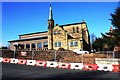
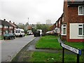
Wall repairs at St Paul's Church in Newham Grange
This photograph shows a view of St Paul's Church in the Newham Grange area of Stockton-on-Tees. The picture was taken from Bishopton Road West (at the junction with Gray's Road) looking in a north-north-westerly direction towards Kirkdale Close.
Image: © Philip Barker
Taken: 10 Mar 2010
0.23 miles
6
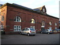
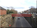
Apartments in former station building, Stockton
Image: © JThomas
Taken: 12 Jan 2013
0.24 miles
7
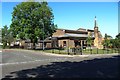
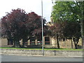
St Paul's ecumenical church, Bishopton Road, Stockton
St Paul's Church is an ecumenical church combining Anglican and Methodist memberships.
Image: © Graham Robson
Taken: 6 Jul 2019
0.24 miles
8
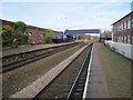
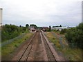
Stockton railway station, County Durham
Opened in 1852 by the Leeds Northern Railway on the line from Northallerton to Billingham, this station was expanded in 1893 when it received an overall roof.
View north east towards Billingham and Sunderland. The roof was removed in 1979, leaving just the substantial supporting wall to the left.
Image: © Nigel Thompson
Taken: 3 Nov 2012
0.25 miles