
IMAGES TAKEN NEAR TO
Christchurch Drive, STOCKTON-ON-TEES, TS18 5JZ
Introduction
This page details the photographs taken nearby to Christchurch Drive, TS18 5JZ by members of the Geograph project.
The Geograph project started in 2005 with the aim of publishing, organising and preserving representative images for every square kilometre of Great Britain, Ireland and the Isle of Man.

There are currently over 7.5m images from over14,400 individuals and you can help contribute to the project by visiting https://www.geograph.org.uk
Image Map
Images are licensed for reuse under creativecommons.org/licenses/by-sa/2.0
Notes
- Clicking on the map will re-center to the selected point.
- The higher the marker number, the further away the image location is from the centre of the postcode.
Image Listing (4 Images Found)
Images are licensed for reuse under creativecommons.org/licenses/by-sa/2.0
Image
Details
Distance
1
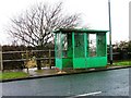
Bus Stop, Green's Lane
I thought the graffiti artists had conveniently put the postcode on (TS20) but I was wrong this is TS18.
Image: © Mick Garratt
Taken: 25 Jan 2006
0.15 miles
2
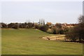
Green belt in Hartburn
This photograph shows a view of a green belt area of parkland near Holy Trinity Rosehill Primary School in Hartburn. The picture was taken looking in an east-north-easterly direction towards Ian Ramsey Church of England School (south site).
Image: © Philip Barker
Taken: 3 Mar 2010
0.17 miles
4
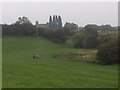
Beck at Greenvale
Beck at Greenvale, taken from Upsall Grove looking East North East towards Ian Ramsey C of E School (behind poplars). NB the school itself is just outside the grid square NZ4118.
Image: © Mick Johnson
Taken: 16 Oct 2006
0.24 miles