IMAGES TAKEN NEAR TO
Rugby Road, STOCKTON-ON-TEES, TS18 4AZ
Introduction
This page details the photographs taken nearby to Rugby Road, TS18 4AZ by members of the Geograph project.
The Geograph project started in 2005 with the aim of publishing, organising and preserving representative images for every square kilometre of Great Britain, Ireland and the Isle of Man.

There are currently over 7.5m images from over14,400 individuals and you can help contribute to the project by visiting https://www.geograph.org.uk
Image Map
Images are licensed for reuse under creativecommons.org/licenses/by-sa/2.0
Notes
- Clicking on the map will re-center to the selected point.
- The higher the marker number, the further away the image location is from the centre of the postcode.
Image Listing (7 Images Found)
Images are licensed for reuse under creativecommons.org/licenses/by-sa/2.0
Image
Details
Distance
6

Hartburn Beck
The brown edges show evidence of the beck's higher level during rainstorms.
Image: © Carol Rose
Taken: 8 Jul 2007
0.24 miles
7
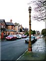
Sewer Ventilation Pipe, Richmond Road, Stockton-on-Tees
Probably Victorian, also the purpose is a guess.
Image: © Mick Garratt
Taken: 25 Jan 2006
0.24 miles