IMAGES TAKEN NEAR TO
Van Mildert Way, STOCKTON-ON-TEES, TS18 3UF
Introduction
This page details the photographs taken nearby to Van Mildert Way, TS18 3UF by members of the Geograph project.
The Geograph project started in 2005 with the aim of publishing, organising and preserving representative images for every square kilometre of Great Britain, Ireland and the Isle of Man.

There are currently over 7.5m images from over14,400 individuals and you can help contribute to the project by visiting https://www.geograph.org.uk
Image Map
Images are licensed for reuse under creativecommons.org/licenses/by-sa/2.0
Notes
- Clicking on the map will re-center to the selected point.
- The higher the marker number, the further away the image location is from the centre of the postcode.
Image Listing (4 Images Found)
Images are licensed for reuse under creativecommons.org/licenses/by-sa/2.0
Image
Details
Distance
1
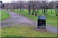
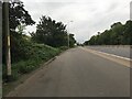
Park off Yarm Road
Area of open space including football pitch in the triangle of land between the railways and Yarm Road.
Image: © Mick Garratt
Taken: 5 Jan 2006
0.05 miles
2
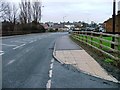
Yarm Road
Looking north east towards Stockton and taken outside the locked carpark for access to the park (see Image]).
Image: © Mick Garratt
Taken: 5 Jan 2006
0.10 miles