IMAGES TAKEN NEAR TO
Hope Gardens, STOCKTON-ON-TEES, TS18 3BY
Introduction
This page details the photographs taken nearby to Hope Gardens, TS18 3BY by members of the Geograph project.
The Geograph project started in 2005 with the aim of publishing, organising and preserving representative images for every square kilometre of Great Britain, Ireland and the Isle of Man.

There are currently over 7.5m images from over14,400 individuals and you can help contribute to the project by visiting https://www.geograph.org.uk
Image Map
Images are licensed for reuse under creativecommons.org/licenses/by-sa/2.0
Notes
- Clicking on the map will re-center to the selected point.
- The higher the marker number, the further away the image location is from the centre of the postcode.
Image Listing (4 Images Found)
Images are licensed for reuse under creativecommons.org/licenses/by-sa/2.0
Image
Details
Distance
2
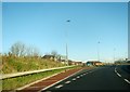
Works access off the A66 at Bowersfield
Image: © Peter Robinson
Taken: 2 Dec 2012
0.09 miles
3
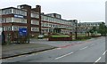
Ashmore House
Taken from just outside the grid square Ashmore House was built as the headquarters of Davy Ashmore Ltd., which came into existence after Power Gas Corporation (established in 1901) merged with Davy United to become Davy Ashmore Ltd. In 1973 it later became known as Davy International Ltd. and in 1980 Davy McKee.
The eighties and nineties saw the amalgamation, mergers and take overs of several well known engineering businesses. Head Wrightson, Redpath Dorman Long and Davy Mckee all lost their identities under the umbrella of commercially successful conglomerate John Brown and Company. John Brown and Company was taken over by Trafalgar House which itself was brought by the Norwegian group of companies Kværner.
In 2004 Aker Maritime and Kværner merged to form Aker Kværner, the current occupiers of the building.
Image: © Mick Garratt
Taken: 10 Oct 2006
0.10 miles
4
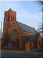
Parish Church of St Peter, Yarm Road, Stockton on Tees
Image: © Bill Henderson
Taken: 20 Feb 2008
0.24 miles