IMAGES TAKEN NEAR TO
Foston Way, STOCKTON-ON-TEES, TS18 2SS
Introduction
This page details the photographs taken nearby to Foston Way, TS18 2SS by members of the Geograph project.
The Geograph project started in 2005 with the aim of publishing, organising and preserving representative images for every square kilometre of Great Britain, Ireland and the Isle of Man.

There are currently over 7.5m images from over14,400 individuals and you can help contribute to the project by visiting https://www.geograph.org.uk
Image Map (Loading...)


Getting Data...Please wait
Leaflet Map data © OpenStreetMap
Images are licensed for reuse under creativecommons.org/licenses/by-sa/2.0
Notes
- Clicking on the map will re-center to the selected point.
- The higher the marker number, the further away the image location is from the centre of the postcode.
Image Listing (47 Images Found)
Images are licensed for reuse under creativecommons.org/licenses/by-sa/2.0
Image
Details
Distance
1
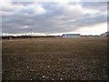
Derelict land awaiting re-development
This photograph shows a view of some derelict land (on the north bank of the River Tees) that is waiting to be re-developed. Part of the Stockton Campus of the University of Durham can just be seen on the horizon on the opposite side of the river. This picture was taken looking in a southerly direction towards Thornaby-on-Tees.
Image: © Philip Barker
Taken: 29 Jan 2010
0.06 miles
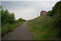

4
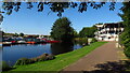
Teesdale Way approaching The Tees Barrage
The way is tarmaced as it follows the river opposite Durham University - Teesside Campus.
Image: © Chris Heaton
Taken: 2 Nov 2010
0.18 miles
5
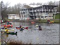
Canoe Club, Tees Barrage
With tyro canoeists learning their skills on the calm waters upstream of the barrage.
Image: © Stanley Howe
Taken: 12 Apr 2013
0.19 miles
6
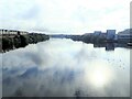
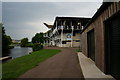
Looking downstream from the Infinity Bridge
Durham University Queen's Campus buildings on the right
Image: © Eirian Evans
Taken: 15 Sep 2021
0.19 miles
7
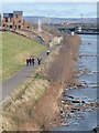
Teesdale Way seen from the Infinity Bridge
The Teesdale Way is a 160 km long distance path running the length of the Tees. Over this stretch in Stockton-on-Tees, it also functions as a cycle path alongside the as yet undeveloped North Shore area. Some new housing can be seen, with the Tees Barrage Image in the middle distance, and the Cleveland Hills on the horizon.
Image: © Oliver Dixon
Taken: 28 Feb 2012
0.19 miles
9
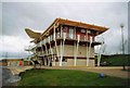
Whitewater Park clubhouse
This building provides changing facilities for the
white water rafters and sailors using the barrage.
Image: © Jack Hill
Taken: 12 Feb 1998
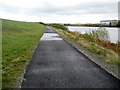
0.20 miles
10
The Tees Barrage White Water Centre
Stockton on Tees.
Image: © Ian S
Taken: 7 Jun 2014
0.20 miles